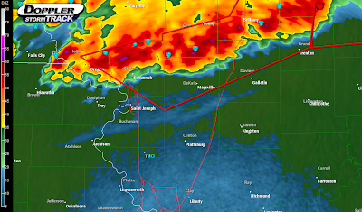
Severe thunderstorm warnings have been issued for this entire line of thunderstorms north of KC. Here is a Level III NEXRAD image from 10:00PM with the warned areas indicated by the red polygons:
 These are very intense thunderstorms but there are some signs that they may be weakening. A 90MPH wind gust was reported with these storms earlier. I still expect these storms to weaken as they push southeast and I believe that they'll impact KC with heavy rain, winds, and hail all below severe levels. I'll update tonight if things change, but if you live north of the metro, please keep a close eye on these thunderstorms. While the tornado threat remains very, very low, a damaging wind threat appears possible for at least another hour. Remember that damaging winds can and do cause damage just as expansive as that caused by tornadoes.
PREVIOUS ENTRY BELOW
**************************
It's June! School's out and warm weather is in- 90 degrees and higher in the sun in most locations this week. But, when it's not warm and muggy thunderstorms seem to be popping up, and strong storms formed in JOCO earlier today prompting a severe thunderstorm warning and triggering some marginally severe hail near Olathe- along with some strong wind gusts and heavy rain. But, for tonight, there is a threat of some thunderstorms (possibly severe) in and around the KC area. Here's a view of the NEXRAD image from 9:15PM this evening:
 Gentry, Harrison, and Worth counties in northern MO are currently under severe thunderstorm warnings. As this is very time sensitive, by the time anyone reads this the warnings will most likely have moved on. The greatest threat with any of these storms will be nickel sized hail and very strong winds, possibly pushing 70MPH in the most dangerous severe thunderstorms tonight. By about midnight, most of us here in KC should start to hear thunder in the distance and maybe see some lightning. 2AM and later is when we can expect to see any thunderstorms-pea size hail and gusty non-severe winds are possible. Heavy rains, maybe a flooding threat in low-lying areas, will also be likely. For a specific severe threat, I'd have to say that KC's threat is extremely low, and by midnight, most of the mid- and upper-level winds, along with the LLJ (low level jet) will have relaxed enough to diminish the severe threat. Before midnight, areas in northern Missouri will continue to have an isolated severe wind threat.
Tomorrow's forecast is incredibly difficult- the front that is accompanying these severe thunderstorms will stall (and disintegrate) across the area tomorrow morning, and after some early thunderstorms, another 80-90 degree day is likely. By afternoon, the weakening stalled front may (will) provide a focus area for thunderstorm development. Wind shear numbers aren't looking great, but instability is looking rather extreme, and any variation in wind shear forecasts could really spike a severe weather forecast. For now, I'd say marginally severe hail and strong winds will be likely with any thunderstorms tomorrow afternoon. If some of the atmospheric wind profiles can pick up a little bit, we may see a higher severe hail threat, and maybe the potential for an isolated tornado or two in the region, but right now winds aren't looking very supportive of a tornado threat.
For the weekend, the jet stream will sag southward and set up a very strong upper level wind force above the KC area, and will allow any surface lows and disturbances to ride this very powerful stream across the area. So, any SFC lows that move towards the area from Saturday through next Wednesday will need to be watched very closely for an increased hail and tornado threat. By June 15th, the tornado threat for our area will be over, and the rest of the summer should be marked by classic summer thunderstorms. I'll keep this updated the next few days, but enjoy some comfortable weather in the shade, and keep an eye to the sky through tomorrow, and this weekend.

No comments:
Post a Comment