Alright, sorry for the really long wait for this blog. . . but the last week has been ridiculously busy, and with finals starting tomorrow, it'll probably be that way for a couple more days. But, right now, I'm taking a break from some of the studying to finally get to discuss the severe weather and bow echo from a couple of weeks ago, and to mention the tornadoes that happened a few days ago around Warrensburg and Sedalia.
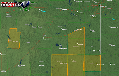
Below is the Level II NEXRAD image from 11:36 on that Thursday night, with arrows drawn in depicting wind flow into and out of the line of thunder
storms.
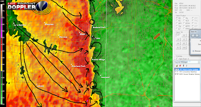
The city in the center of the image is Prairie Village,
with Leawood just to the southeast. I drew in all the rear inflow jet locations (those are the north to south or northwest to southeast arrow) with black. The rear inflow jet is an area of enhanced windflow into the thunderstorm, and, when coupled with enhanced windflow into the thunderstorm from the opposite direction, can lead to 'mesovortices'. Mesovortices are common with bow echo thunderstorms, and are what led to the EF-2 and EF-3 tornadoes in the northland last year. In bow echoes, when shear
and helicity values are high enough, any interaction between the west-east winds of the bow echo and the winds of another thunderstorm, or of a frontal boundary, can trigger the thunderstorm to start rotating, pulling in air from behind (the rear inflow jet) and wrapping winds from the south into the thunderstorm (indicated by the black arrows that move in a curved line generally to the northwest). When this happened, the change in wind profiles are picked up by doppler radar, and small 'hooks' or notches can form on the radar. These are extremely small areas where wind convergence from the bow echo and another atmospheric convective feature is strong enough to produce a brief (but usually strong) circulation. NEXRAD picked up on this and indicated NRO
T (Normalized ROTation) values close to or exceeding '1' around this time, which is typically the threshold where a tornado appears possible. But sometimes, in bow echoes, the west to east winds are so strong that, while a brief circulation is attained with interaction with another convective feature, the winds are only strengthened or pushed closer to the ground, which can often lead to intense downbursts, which are usually localized and known as 'microbursts'. Microbursts cause tornado-like damage, last for only a few minutes or less, and on radar can be hard to discern from tornadoes in severe weather situations. What happened on Thursday, I believe, was a situation where two very small but intense microbursts sent 70MPH+ winds roaring through parts of Olathe and Gardner, indicated by the damage in small areas. Also, the damage was in a relatively straight line. Tor
nado damage is generally very strewn about and sometimes a circular pattern is apparent. This was obviously not the case. But, in DeSoto, where a barn was destroyed, but the houses around virtually untouched, one would have to think that the possibility of a microburst was relatively small considering the microscopic range
of the winds and damage. A localized straight line wind gust or tornado may have been responsible. In bow echoes, when tornadoes do form, they typically only remain on the ground for a few seconds at the most, causing little or no damage to 1 or 2 structures, which I think was very possible in this area.
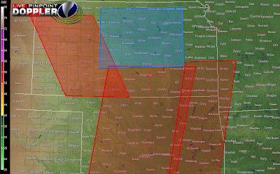
Below is the radar image with windflow drawn in around the time the damage was reported in JOCO. A notch is visible in the radar just to the northeast of DeSoto.
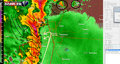
Any of these 'mesovortices', which are indicated when two areas are pointing nearly directly at each other, have the potential to produce a brief but strong downburst, wind gust, funnel cloud, or tornado. I was watching this very closely of course, and as the storms approached NE JOCO, where I live, I continued to notice the mesovortices and lack of proper warning by media outlets.
Regardless of the type of severe weather occuring, be it tornado or damaging winds, the storm produced damage that was severe enough to be considered life-threatening, and so I think that local media have a responsibility to cover situations like this.
But back to the mesovortices. . . as the storm approached my home, my ears suddenly popped and I heard a loud whooshing sound, I looked outside, and the wind was blowing stronger than I think I've ever seen it, even in a thunderstorm. My ears continued to hurt, and I took shelter downstairs, but the winds subsided within 30 seconds. The next morning, no damage was to be seen. So what happened? Well, first of all, straight-line winds don't normally produce a 'whooshing' sound unless the winds are strong enough to cause severe structural damage. But, funnel clouds can trigger ground pressure changes (i.e. ear popping) and a whooshing sound near by them. While I don't believe the circulation reached the ground, the already gusty winds of the storm may have created a tornado-like scene outside, which is what I saw. Even so, I believe there were probably numerous funnels over head, something most of us couldn't see because of how late at night it was.
So, in conclusion, a mix of severe weather probably occurred. And, tornado-like damage was the result of these dangerous storms. So the message is to take shelter whenever you hear a severe thunderstorm OR tornado warning has been issued. Severe thunderstorms can produce just as much damage as tornadoes but are often not covered as extensively as tornadoes because severe thunderstorms don't carry the connotation that they are highly damaging. I hope all of this made sense, and please share your thoughts!
Anyway, onto the other day near Sedalia. The surface low and front was located nearby, creating ample shear for any surface based storms that formed in the stable environment to produce brief and weak tornadoes, which is what happened. NROT values never indicated a tornado vortex signature or mesocyclone, because of the extremely brief and weak natures of these storms. Luckily, no significant damage was reported and most of the time the storms were in unpopulated areas, but did get frighteningly close to Sedalia.
As for this week- FINALLY! It's hit 80 degrees! And, every day this week we should exceed the 80 degree mark. We might even reach 90 one day this week if the saturated grounds can have some of their water evaporate. A deep ridge has built in over the west, keeping all storm systems well away from KC, and an area of very high pressure has set in. However, if for some odd reason, diurnal surface storms pop up in an extremely scattered fashion, they will warrant some watching as instability is high and marginally severe weather would be possible. But, for the most part, I think this week should be dry and hot! No significant severe weather, but looking at the extended GFS I see at least one. . . maybe two more severe weather days for KC this year, some of which might be more widespread than our prior attempts this year, as warmer air is finally surging in. The earliest chance for any storms is more than a week away, so enjoy the warm air, and make sure to drink plenty of water and wear sunscreen if you're going to be spending a lot of time outside to prevent heat exhaustion and sunburn. Have a great week!


 I'll update later tonight or in the morning. So many questions in this forecast- I hope my analysis made some sense. Have a good night and keep an eye on the weather for tomorrow evening.
 And as for the rest of the night- isolated showers with a rumble of thunder possible will continue, primarily on the MO side, for a few more hours. Again, no severe weather threat. Tomorrow should be a great day- forecast high in the lower 70s, finally- some spring weather.
 As for today, a very tragic situation developed over eastern Oklahoma resulting in the deaths of 5 people. But stories of heroism and true miracles have also surfaced. I have deep sympathy for the friends and families of those that parished. Unfortunately, not only did VORTEX2 not gain much data today but the tornados they were following were generally in densely populated areas, like the tornado in OKC. Check out KWTV and KOCO in OKC and KSN and KAKE in Wichita for more information.
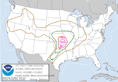
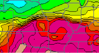
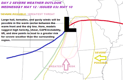
 Severe hail and wind gusts will be possible in far south and southeast KS, extreme southwest MO, far northwest AK, and, along with a continued risk for isolated strong and long-track tornadoes, through eastern OK into north central and northeast Texas. This activity will all be between the dry line (shown on the map in tan) and the warm front (in red) where the warm sector is promoting a very unstable environment, something we lack here, effectively eliminating all severe weather threat for Kansas City.