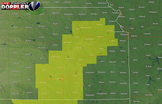
Funnels have already been reported over central KS, near Hutchinson, and a tornado has just been confirmed on the ground northeast of the city, near McPherson. Multiple tornado warnings and numerous severe thunderstorm warnings are in effect for the western portions of Tornado Watch #155 (which includes Jefferson and Douglas Co. in Kansas). These thunderstorms are primarily linear but have embedded supercellular structures allowing for a significant tornado threat with these thunderstorms. The warm front is moving through the KC area right now, with temperatures in JOCO in the upper 70s, but only 61 at MCI Airport. Clouds have held over KC but instability is growing with the advancement of the warm front. A relatively strong cap is holding in the atmosphere over KC, but has already been broken just west of Wichita. This has led me to shift my 'Greatest Risk' area to the southwest, and I've left KC out of that outlook region. I believe the highest tornado threat will be well southwest of KC today, with atmospheric conditions becoming more probably there with the already unstable and saturated environment. I've included KC in the 'Likely' area because of a significant threat for large, damaging hail, and isolated tornados. Farther to the north and east, large hail will still be possible, in some of the stronger storms ahead of the warm front. That is why I've kept those locations in the 'Possible' area for severe weather. As for here in KC, please continue to monitor this situation as the situation in southern Kansas is quickly involving into a
significant severe weather event. Large, damaging hail will be the greatest threat with any of these storms. I've posted my updated outlook for tonight along with a tornado watch graphic below. I'll update later on.


No comments:
Post a Comment