 I'll update later if possible, but pay heed to NWS warnings and if reports continue to come in of 70-80MPH winds, it wouldn't be a bad idea to head to the lowest level and center part of your house. Remember, a severe thunderstorm warning doesn't indicate a lower danger than that contained within a tornado warning, it only indicates a different type of danger. Severe thunderstorms can produce winds that easily cause more damage than many tornadoes. Have a good and safe night everyone!
Saturday, June 19, 2010
More Storms Tonight
After a record breaking derecho tracked from eastern Nebraska all the way to Ohio yesterday we have been rocked with two significant thunderstorm events, one last night that produced storms to the north, and another coming in from the northwest earlier this afternoon which produced some scattered tree damage around the area with 60MPH+ winds. But, tonight, another bow echo (which is basically a line of thunderstorms with a bloated midsection indicating higher winds) is approaching from the west. It currently lies west of Topeka, but is packing potential 80MPH+ winds, and, as is always possible with bow echos, the chance for brief, but strong, spin-up tornadoes. We're under a severe thunderstorm watch until 3AM, and unless the thunderstorms weaken, we'll be in for a very significant event tonight. I didn't blog about the event earlier today for a number of reasons, one, it was a broken line, and, two, the reports weren't of extensive damage. I knew wind damage would be sparse, but tonight's situation may be a different story. Please take care to secure all outdoor furniture that could become debris in straight-line winds. Here is a graphic of the watch area: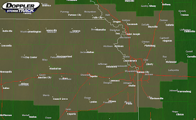 I'll update later if possible, but pay heed to NWS warnings and if reports continue to come in of 70-80MPH winds, it wouldn't be a bad idea to head to the lowest level and center part of your house. Remember, a severe thunderstorm warning doesn't indicate a lower danger than that contained within a tornado warning, it only indicates a different type of danger. Severe thunderstorms can produce winds that easily cause more damage than many tornadoes. Have a good and safe night everyone!
I'll update later if possible, but pay heed to NWS warnings and if reports continue to come in of 70-80MPH winds, it wouldn't be a bad idea to head to the lowest level and center part of your house. Remember, a severe thunderstorm warning doesn't indicate a lower danger than that contained within a tornado warning, it only indicates a different type of danger. Severe thunderstorms can produce winds that easily cause more damage than many tornadoes. Have a good and safe night everyone!
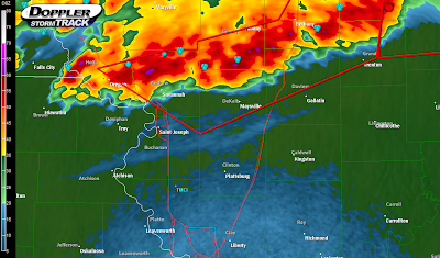
Friday, June 18, 2010
Tornadic Thunderstorms Up North
As of 11:15 PM the NWS has issued two severe thunderstorm warnings for parts of Daviess, Caldwell, Clinton, Andrew, Doniphan, Buchanan, and DeKalb counties after the tornado warning expired at 10:45. . . however the rotation still looks strong enough to me to easily produce a pretty strong, but quick, tornado, so if you have relatives up near Stewartsville, Osborn, Cameron, Amity, Maysville, and Clarksdale, let them know they should be keeping a close eye on this. Areas closer to St. Joseph have a much lower tornado threat but regardless of the tornado threat (funnels were spotted earlier near Union Hill) 70MPH straight-line winds and quarter-size hail stones are possible with these thunderstorms. This line of storms may hit KC within a couple of hours and may retain some of its strength, but right now I don't think it will, however it'd be a good idea to sleep with your weather radio on alert mode to warn you just in case. If anything major happens, I'll update, and have a good night everyone! Below is the NEXRAD image from 11:15.
 One last thing- the NWS, sensing the potential tornado threat, included this message in its latest warning text:
THIS IS A SUPERCELL THUNDERSTORM. DUE TO THE ROTATING NATURE OF THESE
STORMS...THEY ARE CAPABLE OF PRODUCING ALL TYPES OF SEVERE WEATHER...
INCLUDING EXTREMELY LARGE HAIL...DESTRUCTIVE STRAIGHT LINE WINDS AND
POSSIBLY TORNADOES. MOVE QUICKLY TO A SAFE SHELTER...PREFERABLY INTO
AN INTERIOR ROOM...SUCH AS A BATHROOM OR A CLOSET...OR INTO A
BASEMENT.
Sunday, June 13, 2010
Severe Thunderstoms Moving Into KC
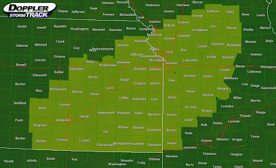
 In the map above, the grayed in area is under a Severe Thunderstorm Watch. This will likely be extended eastward in the coming hours. These thunderstorms, which are now moving into Douglas county, will affect the entire KC region with damaging winds up to 70-80MPH, frequent cloud to ground lightning, small hail, and the potential for microbursts and brief spin up tornadoes, so it's a good idea to be in a safe place in your home as these move through.
Saturday, June 12, 2010
Flash Flooding is Likely Today
Flash Flood Warnings were issued across the metro this morning for the torrential rains produced by a morning MCS. Many locations received 2-4" of rain. This evening, thunderstorms should reform and it is very important to keep a close eye on Flash Flood Warnings, if and when they are issued. Here are some tips for flash flooding:
Also this evening is a slight risk of severe weather. Any thunderstorms that become particularly strong will have a risk of producing some isolated damaging winds and marginally severe hail. Shear and helicity are very low today for this area, so the chance of any tornadoes is close to none. But, we can't rule out the possibility of a weak tornado along the front. The map below shows the cold front, low pressure centers, and severe weather risks.
 So tonight, the main risk, and very deadly risk, is flash flooding. There is a limited threat for severe weather, and a near-zero risk for tornadoes. If anything changes, I'll post again later, but for now, enjoy the last couple of hours of warm temperatures, clear skies, and dryer air! I will mention that the dewpoints are climbing toward 75, so it is beginning to get humid. Have a nice evening!
- Never drive through flooded roadways unless it is an absolute must, and even then, only if the water is not flowing or is flowing slowly and is less than 6" in depth. If you cannot tell how high the water is, do not cross in any circumstances.
- Flooding is likely in any low lying areas. Make sure that pets, lawn furniture, balls, etc. are on higher land this evening. Water that isn't even up to the top of the grass can sweep many things away.
- Floods may reach your house. If so, do not exit unless critical for your safety, remove the power source from any exterior electronics and electrical plugs, and put sandbags around your doors if possible.
Also this evening is a slight risk of severe weather. Any thunderstorms that become particularly strong will have a risk of producing some isolated damaging winds and marginally severe hail. Shear and helicity are very low today for this area, so the chance of any tornadoes is close to none. But, we can't rule out the possibility of a weak tornado along the front. The map below shows the cold front, low pressure centers, and severe weather risks.
 So tonight, the main risk, and very deadly risk, is flash flooding. There is a limited threat for severe weather, and a near-zero risk for tornadoes. If anything changes, I'll post again later, but for now, enjoy the last couple of hours of warm temperatures, clear skies, and dryer air! I will mention that the dewpoints are climbing toward 75, so it is beginning to get humid. Have a nice evening!
Tuesday, June 8, 2010
Tornado Watch
4:40PM UPDATE
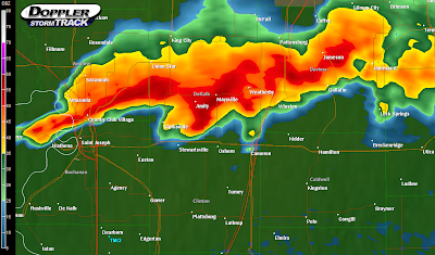
Severe thunderstorm warnings are now being issued across the tornado watch. Here's a radar image from 4:40 of the supercell south of KC near Spring Hill. This thunderstorm can produce 70MPH winds and baseball sized hail. Some rotation has been observed, so pay close eye to all future warnings. Keep a weather radio close by tonight!
 PREVIOUS ENTRY BELOW
-------------------------------
Most of the area is now under Tornado Watch #285 effective until 9PM tonight. The counties in the watch are highlighted in yellow in the image below.
 Conditions are favorable for, possibly, our biggest severe weather event of the year. Isolated tornadoes, very large hail, and wind gusts are likely with the thunderstorms that, as of right now, are rapidly developing and intensifying. None of the thunderstorms are severe right now, but are dropping torrential rains with 1" per hour rainfall rates. Flash flooding is a major concern, especially in northern Missouri. Remember, do not cross roadways that are covered by water. 6" of water can sweep a car away. I'll update in a few minutes.
Severe Thunderstorm Watch
8:00AM UPDATE
Alright, this is just a quick update that the storms are making there way into the KC area, and they have weakened below severe limits. Lots of lighting, heavy rain, a wind gust or too, and maybe some pea sized hail in some places is possible with these thunderstorms. I'll update in a few hours on tonight's severe potential.
PREVIOUS ENTRY(S) BELOW
-------------------------------
The SPC has issued Severe Thunderstorm Watch 284 effective immediately and expiring at 9AM CDT for portions of the KC area, from the 2nd tier of counties in eastern KS to points westward into central KS. A map with the watch regions highlighted is below. You can also see the radar picking up the leading edge of a bow-echo in north central KS and southern NE. These storms are very strong, packing winds up to 70MPH, and some gusts may be even higher.
 If this bow echo holds together and retains the strong winds, it should pull through KC around 8AM this morning with the possibility for severe winds. I have relatively high confidence in the timing of these thunderstorms that are associated with an MCS, or mesoscale convective system, which is simply a large mass of thunderstorms all behaving in a similar fashion, and moving in a similar direction.
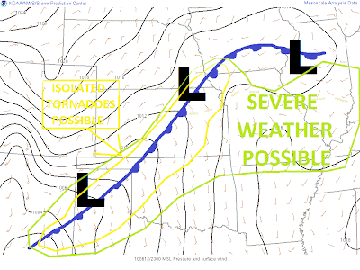
As for the rest of tomorrow, below is my revised version of the SPC Day 1 outlook. I believe that tomorrow afternoon, more severe thunderstorms will develop along or just north of I-70, and that they'll push southward with large hail, damaging wind, and possibly a couple of isolated tornadoes. I'm not sure how readable my text is there, so sorry for that. But, what it contains is reference to my forecast that the highest tornado threat will be confined to along and just south of the front, which may set up anywhere from north central MO to just south of KC. Right now, my best guess and the best guess of the NWS using the NAM model is that the front will set up along I-70 and stretch northeast into IL.
For tonight's storms, around 8AM you can expect some thunder around, severe weather possible so keep a weather radio on if you won't be up by then. I think that the storms may weaken, but we'll just have to see. Have a great night everyone! And, I'll update before 8AM if the storms continue to be severe.
Alright, this is just a quick update that the storms are making there way into the KC area, and they have weakened below severe limits. Lots of lighting, heavy rain, a wind gust or too, and maybe some pea sized hail in some places is possible with these thunderstorms. I'll update in a few hours on tonight's severe potential.
PREVIOUS ENTRY(S) BELOW
-------------------------------
The SPC has issued Severe Thunderstorm Watch 284 effective immediately and expiring at 9AM CDT for portions of the KC area, from the 2nd tier of counties in eastern KS to points westward into central KS. A map with the watch regions highlighted is below. You can also see the radar picking up the leading edge of a bow-echo in north central KS and southern NE. These storms are very strong, packing winds up to 70MPH, and some gusts may be even higher.
 If this bow echo holds together and retains the strong winds, it should pull through KC around 8AM this morning with the possibility for severe winds. I have relatively high confidence in the timing of these thunderstorms that are associated with an MCS, or mesoscale convective system, which is simply a large mass of thunderstorms all behaving in a similar fashion, and moving in a similar direction.
As for the rest of tomorrow, below is my revised version of the SPC Day 1 outlook. I believe that tomorrow afternoon, more severe thunderstorms will develop along or just north of I-70, and that they'll push southward with large hail, damaging wind, and possibly a couple of isolated tornadoes.
 I'm not sure how readable my text is there, so sorry for that. But, what it contains is reference to my forecast that the highest tornado threat will be confined to along and just south of the front, which may set up anywhere from north central MO to just south of KC. Right now, my best guess and the best guess of the NWS using the NAM model is that the front will set up along I-70 and stretch northeast into IL.
For tonight's storms, around 8AM you can expect some thunder around, severe weather possible so keep a weather radio on if you won't be up by then. I think that the storms may weaken, but we'll just have to see. Have a great night everyone! And, I'll update before 8AM if the storms continue to be severe.
Monday, June 7, 2010
Severe Weather Potential. . . Tonight and Tomorrow
12:15 AM UPDATE
The MCS has developed and is moving much more to the south now than previously projected by any forecasters. This mass of thunderstorms has triggered a bow echo in central Nebraska that is moving toward Hastings and will push into north-central and northeastern KS later this morning (probably near dawn or slightly earlier). This is very important in tracking severe weather, as our atmosphere is modestly unstable, and if the bow echo holds together, we may see some damaging winds as this moves into NW and west-central Missouri. I still think it will exit in time for more afternoon storms tomorrow. I'll update later. Thanks for checking in!
PREVIOUS ENTRY BELOW
-------------------------------------
 The next image is the reflectivity from the same time, with an arrow and a circle placed into and around the area where the tornado is likely forming. The line indicates the inflow into the thunderstorm. This is a classic example of a 'hook echo' with a supercell.
 These thunderstorms will likely form into an 'MCS', or 'mesoscale convective system'. They are very far north and west of KC- nearly 400 miles away. They will near our region very late tonight into early tomorrow morning, and may even affect going to work traffic. Northern Missouri has the best threat to see any thunderstorms, mainly north of Highway 36. As they continue on their path, they might dip into the area, but right now I somewhat doubt the contact of the MCS with Kansas City. For the high, I'm thinking we'll reach 90-95 if, and only if, the MCS doesn't come into contact with KC and we are able to clear the clouds out bringing us sun and daytime heating. If we do have rain and thunderstorms tomorrow, mainly in the morning to late morning, we may only get up to 85 or so, and that high may come before the MCS reaches KC. If the MCS does impact KC, strong wind gusts and maybe some large hail would be the threats. But, if we have time to heat up tomorrow, then the main threat would be later in the afternoon as the warm front/cold front approaches KC. These thunderstorms would likely be very severe, with very large hail and damaging winds the greatest threats, although we may have a few tornadoes, especially along and just south of the front which is forecast to be near I-70. However, the tornado threat is still relatively low. I'll update if I get new model data, but enjoy a few quiet hours and be ready for storms tomorrow!
And a quick note to anyone in northern MO- heavy rain is likely with this MCS, maybe on the scale of up to 3". Flash flooding is likely in these areas, so remember to avoid low lying areas, and to never drive across water-covered roadways. Pay close attention to NWS Flash Flood Warnings.
Tuesday, June 1, 2010
June 1st
10:00PM UPDATE
Severe thunderstorm warnings have been issued for this entire line of thunderstorms north of KC. Here is a Level III NEXRAD image from 10:00PM with the warned areas indicated by the red polygons:
 These are very intense thunderstorms but there are some signs that they may be weakening. A 90MPH wind gust was reported with these storms earlier. I still expect these storms to weaken as they push southeast and I believe that they'll impact KC with heavy rain, winds, and hail all below severe levels. I'll update tonight if things change, but if you live north of the metro, please keep a close eye on these thunderstorms. While the tornado threat remains very, very low, a damaging wind threat appears possible for at least another hour. Remember that damaging winds can and do cause damage just as expansive as that caused by tornadoes.
PREVIOUS ENTRY BELOW
**************************
It's June! School's out and warm weather is in- 90 degrees and higher in the sun in most locations this week. But, when it's not warm and muggy thunderstorms seem to be popping up, and strong storms formed in JOCO earlier today prompting a severe thunderstorm warning and triggering some marginally severe hail near Olathe- along with some strong wind gusts and heavy rain. But, for tonight, there is a threat of some thunderstorms (possibly severe) in and around the KC area. Here's a view of the NEXRAD image from 9:15PM this evening: Gentry, Harrison, and Worth counties in northern MO are currently under severe thunderstorm warnings. As this is very time sensitive, by the time anyone reads this the warnings will most likely have moved on. The greatest threat with any of these storms will be nickel sized hail and very strong winds, possibly pushing 70MPH in the most dangerous severe thunderstorms tonight. By about midnight, most of us here in KC should start to hear thunder in the distance and maybe see some lightning. 2AM and later is when we can expect to see any thunderstorms-pea size hail and gusty non-severe winds are possible. Heavy rains, maybe a flooding threat in low-lying areas, will also be likely. For a specific severe threat, I'd have to say that KC's threat is extremely low, and by midnight, most of the mid- and upper-level winds, along with the LLJ (low level jet) will have relaxed enough to diminish the severe threat. Before midnight, areas in northern Missouri will continue to have an isolated severe wind threat.
Tomorrow's forecast is incredibly difficult- the front that is accompanying these severe thunderstorms will stall (and disintegrate) across the area tomorrow morning, and after some early thunderstorms, another 80-90 degree day is likely. By afternoon, the weakening stalled front may (will) provide a focus area for thunderstorm development. Wind shear numbers aren't looking great, but instability is looking rather extreme, and any variation in wind shear forecasts could really spike a severe weather forecast. For now, I'd say marginally severe hail and strong winds will be likely with any thunderstorms tomorrow afternoon. If some of the atmospheric wind profiles can pick up a little bit, we may see a higher severe hail threat, and maybe the potential for an isolated tornado or two in the region, but right now winds aren't looking very supportive of a tornado threat.
For the weekend, the jet stream will sag southward and set up a very strong upper level wind force above the KC area, and will allow any surface lows and disturbances to ride this very powerful stream across the area. So, any SFC lows that move towards the area from Saturday through next Wednesday will need to be watched very closely for an increased hail and tornado threat. By June 15th, the tornado threat for our area will be over, and the rest of the summer should be marked by classic summer thunderstorms. I'll keep this updated the next few days, but enjoy some comfortable weather in the shade, and keep an eye to the sky through tomorrow, and this weekend.
Severe thunderstorm warnings have been issued for this entire line of thunderstorms north of KC. Here is a Level III NEXRAD image from 10:00PM with the warned areas indicated by the red polygons:
 These are very intense thunderstorms but there are some signs that they may be weakening. A 90MPH wind gust was reported with these storms earlier. I still expect these storms to weaken as they push southeast and I believe that they'll impact KC with heavy rain, winds, and hail all below severe levels. I'll update tonight if things change, but if you live north of the metro, please keep a close eye on these thunderstorms. While the tornado threat remains very, very low, a damaging wind threat appears possible for at least another hour. Remember that damaging winds can and do cause damage just as expansive as that caused by tornadoes.
PREVIOUS ENTRY BELOW
**************************
It's June! School's out and warm weather is in- 90 degrees and higher in the sun in most locations this week. But, when it's not warm and muggy thunderstorms seem to be popping up, and strong storms formed in JOCO earlier today prompting a severe thunderstorm warning and triggering some marginally severe hail near Olathe- along with some strong wind gusts and heavy rain. But, for tonight, there is a threat of some thunderstorms (possibly severe) in and around the KC area. Here's a view of the NEXRAD image from 9:15PM this evening:
 Gentry, Harrison, and Worth counties in northern MO are currently under severe thunderstorm warnings. As this is very time sensitive, by the time anyone reads this the warnings will most likely have moved on. The greatest threat with any of these storms will be nickel sized hail and very strong winds, possibly pushing 70MPH in the most dangerous severe thunderstorms tonight. By about midnight, most of us here in KC should start to hear thunder in the distance and maybe see some lightning. 2AM and later is when we can expect to see any thunderstorms-pea size hail and gusty non-severe winds are possible. Heavy rains, maybe a flooding threat in low-lying areas, will also be likely. For a specific severe threat, I'd have to say that KC's threat is extremely low, and by midnight, most of the mid- and upper-level winds, along with the LLJ (low level jet) will have relaxed enough to diminish the severe threat. Before midnight, areas in northern Missouri will continue to have an isolated severe wind threat.
Tomorrow's forecast is incredibly difficult- the front that is accompanying these severe thunderstorms will stall (and disintegrate) across the area tomorrow morning, and after some early thunderstorms, another 80-90 degree day is likely. By afternoon, the weakening stalled front may (will) provide a focus area for thunderstorm development. Wind shear numbers aren't looking great, but instability is looking rather extreme, and any variation in wind shear forecasts could really spike a severe weather forecast. For now, I'd say marginally severe hail and strong winds will be likely with any thunderstorms tomorrow afternoon. If some of the atmospheric wind profiles can pick up a little bit, we may see a higher severe hail threat, and maybe the potential for an isolated tornado or two in the region, but right now winds aren't looking very supportive of a tornado threat.
For the weekend, the jet stream will sag southward and set up a very strong upper level wind force above the KC area, and will allow any surface lows and disturbances to ride this very powerful stream across the area. So, any SFC lows that move towards the area from Saturday through next Wednesday will need to be watched very closely for an increased hail and tornado threat. By June 15th, the tornado threat for our area will be over, and the rest of the summer should be marked by classic summer thunderstorms. I'll keep this updated the next few days, but enjoy some comfortable weather in the shade, and keep an eye to the sky through tomorrow, and this weekend.
Subscribe to:
Posts (Atom)
