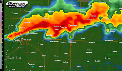
As of 11:15 PM the NWS has issued two severe thunderstorm warnings for parts of Daviess, Caldwell, Clinton, Andrew, Doniphan, Buchanan, and DeKalb counties after the tornado warning expired at 10:45. . . however the rotation still looks strong enough to me to easily produce a pretty strong, but quick, tornado, so if you have relatives up near Stewartsville, Osborn, Cameron, Amity, Maysville, and Clarksdale, let them know they should be keeping a close eye on this. Areas closer to St. Joseph have a much lower tornado threat but regardless of the tornado threat (funnels were spotted earlier near Union Hill) 70MPH straight-line winds and quarter-size hail stones are possible with these thunderstorms. This line of storms may hit KC within a couple of hours and may retain some of its strength, but right now I don't think it will, however it'd be a good idea to sleep with your weather radio on alert mode to warn you just in case. If anything major happens, I'll update, and have a good night everyone! Below is the NEXRAD image from 11:15.
One last thing- the NWS, sensing the potential tornado threat, included this message in its latest warning text:
THIS IS A SUPERCELL THUNDERSTORM. DUE TO THE ROTATING NATURE OF THESE
STORMS...THEY ARE CAPABLE OF PRODUCING ALL TYPES OF SEVERE WEATHER...
INCLUDING EXTREMELY LARGE HAIL...DESTRUCTIVE STRAIGHT LINE WINDS AND
POSSIBLY TORNADOES. MOVE QUICKLY TO A SAFE SHELTER...PREFERABLY INTO
AN INTERIOR ROOM...SUCH AS A BATHROOM OR A CLOSET...OR INTO A
BASEMENT.
 One last thing- the NWS, sensing the potential tornado threat, included this message in its latest warning text:
No comments:
Post a Comment