Severe thunderstorm warnings are now being issued across the tornado watch. Here's a radar image from 4:40 of the supercell south of KC near Spring Hill. This thunderstorm can produce 70MPH winds and baseball sized hail. Some rotation has been observed, so pay close eye to all future warnings. Keep a weather radio close by tonight!
 PREVIOUS ENTRY BELOW
-------------------------------
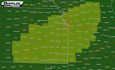
Most of the area is now under Tornado Watch #285 effective until 9PM tonight. The counties in the watch are highlighted in yellow in the image below.
 Conditions are favorable for, possibly, our biggest severe weather event of the year. Isolated tornadoes, very large hail, and wind gusts are likely with the thunderstorms that, as of right now, are rapidly developing and intensifying. None of the thunderstorms are severe right now, but are dropping torrential rains with 1" per hour rainfall rates. Flash flooding is a major concern, especially in northern Missouri. Remember, do not cross roadways that are covered by water. 6" of water can sweep a car away. I'll update in a few minutes.

It was so rainy on the 8! I was at this high school in Prairie Village for a dance recital and the cafeteria that the dancers were in had this glass ceiling type thing so we basically watched the rain pouring off the roof, it was actually very interesting.
ReplyDeleteI know, the rains got so heavy! I woke up early just in case there was any severe weather, and the non-severe storms were moving in right at 8!
ReplyDelete