12:15 AM UPDATE
The MCS has developed and is moving much more to the south now than previously projected by any forecasters. This mass of thunderstorms has triggered a bow echo in central Nebraska that is moving toward Hastings and will push into north-central and northeastern KS later this morning (probably near dawn or slightly earlier). This is very important in tracking severe weather, as our atmosphere is modestly unstable, and if the bow echo holds together, we may see some damaging winds as this moves into NW and west-central Missouri. I still think it will exit in time for more afternoon storms tomorrow. I'll update later. Thanks for checking in!
PREVIOUS ENTRY BELOW
-------------------------------------
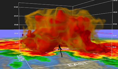
 The next image is the reflectivity from the same time, with an arrow and a circle placed into and around the area where the tornado is likely forming. The line indicates the inflow into the thunderstorm. This is a classic example of a 'hook echo' with a supercell.
 These thunderstorms will likely form into an 'MCS', or 'mesoscale convective system'. They are very far north and west of KC- nearly 400 miles away. They will near our region very late tonight into early tomorrow morning, and may even affect going to work traffic. Northern Missouri has the best threat to see any thunderstorms, mainly north of Highway 36. As they continue on their path, they might dip into the area, but right now I somewhat doubt the contact of the MCS with Kansas City. For the high, I'm thinking we'll reach 90-95 if, and only if, the MCS doesn't come into contact with KC and we are able to clear the clouds out bringing us sun and daytime heating. If we do have rain and thunderstorms tomorrow, mainly in the morning to late morning, we may only get up to 85 or so, and that high may come before the MCS reaches KC. If the MCS does impact KC, strong wind gusts and maybe some large hail would be the threats. But, if we have time to heat up tomorrow, then the main threat would be later in the afternoon as the warm front/cold front approaches KC. These thunderstorms would likely be very severe, with very large hail and damaging winds the greatest threats, although we may have a few tornadoes, especially along and just south of the front which is forecast to be near I-70. However, the tornado threat is still relatively low. I'll update if I get new model data, but enjoy a few quiet hours and be ready for storms tomorrow!
And a quick note to anyone in northern MO- heavy rain is likely with this MCS, maybe on the scale of up to 3". Flash flooding is likely in these areas, so remember to avoid low lying areas, and to never drive across water-covered roadways. Pay close attention to NWS Flash Flood Warnings.

No comments:
Post a Comment