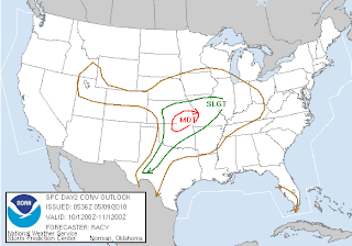
SPC has updated their Day 2 convective outlook- KC is on the far northeast edge of the new MODERATE risk area as shown below. This is relatively in line with my belief that while a critical situation will evolve south of here in relation to tornadoes, KC's best bet will be very large hail and gusty winds. Isolated tornadoes will still be possible, especially in discrete storms, something to watch much more closely than we normally would in spring events. If daytime heating increases our CAPE values may skyrocket leading
to increased tornado threat. I'll update in the morning; we should have a much better grasp on the situation late tomorrow. SPC outlook below.

No comments:
Post a Comment