As the day goes on, severe weather chances continue to diminish for KC and the surrounding area. However, farther to the southwest, large and destructive tornadoes have been reported from near Wichita south to Oklahoma City, and this threat is now moving eastward. KAKE and KSN are two local affiliates in Wichita with live streaming coverage of this event. Cold drizzle and mist continues around KC, keeping surface instability low. The only possible way for our severe threat to increase would be for the warm sector (between the dryline and warm front) to move over KC late tonight. Based on current positioning, this appears to be possible, although not, by any means, likely. I'll keep updating the blog, but right now the best chance for significant severe weather would appear to be focused well to the south of the area. Remember that elevated supercells will still be possible, with some large hail in the stronger storms. It is important, however, to remember that as this situation evolves things may change. Continue to pay close attention to media coverage as the weather can become serious very quickly, something that KC is very used to. So, while right now scattered large hail appears to be the main threat in KC, isolated tornadoes are always possible in supercells, although if I had to put a number on it, I'd say there would be less than a 10% chance that EAX's CWA will see a tornado warning tonight. Below are a few maps of the current severe weather watch situation, along with a radar image of the destructive tornado south of Wichita from a little over an hour ago.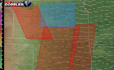


No comments:
Post a Comment