***Clay, Jackson, Platte, Johnson, Wyandotte, and Leavenworth counties in the KC metro are now under an Urban and Small Stream Flood Advisory. . . which will expire in a little over an our. Localized reports of flooding are very sparse but today's heavy rains are triggering the NWS to issue this advisory as a precaution more than anything else. ***
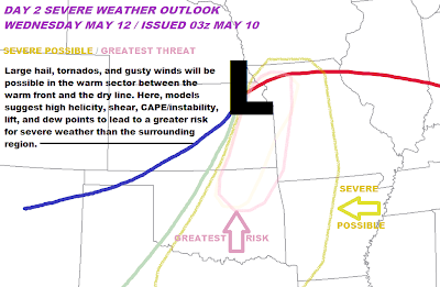
Again, no severe weather tonight. Just cool temperatures- and we'll see a beautiful warm up. We might be pushing 75. . . although for a high I'd put it 69-72 degrees. Tomorrow night, a few small storms might pop up around the area, any of these being capable of producing small hail, occasionally meeting severe limits. The greater threat will come on Wednesday. Check out the surface map I drew for 7-9PM on Wednesday, right now, parameters and winds are indicating a narrow corridor for potential severe weather development- always between the warm front and the dryline. However, on Wednesday, I believe the front will easily clear the KC metro, possibly nearing the MO-IA border. The low will be positioned in northeast KS, with a dryline extending into Oklahoma. Along the boundaries, where convergence will be maximized, sheer parameters and pooling boundary layer moisture should support surface-based supercells for at least a few hours in the late afternoon and evening on Wednesday. This set up will likely be similar to our set up for today, except with the warm front pushing much farther north. Of course, pegging any threat of 'strong, long-track' tornados will wait for tomorrow. Conditions may not be quite as favorable compared to today in the upper levels for supercells to hold onto their rotation characteristics for a long period of time. Even so, current indications point to all of the necessary conditions coming together and translating into a potentially concerning event. . . and upper level characteristics should be more than sufficient, but, like I said, not as extreme as today. Of course we're still close to 48 hours out, but I went ahead and indicated an increased severe weather threat along the dry line for the late evening. No need for apprehension as I know there was high tension in anticipation of today's outbreak, which eventually resulted in a complete bust for most of east KS and west MO. I layed out my forecast concerns last night and they verified, and I will do the same tomorrow night. However, I will say that 48 hours out from this event there is less model disagreement and less indications that any one necessary component for severe weather will fail to materialize. If any concerns do develop, for or against severe weather, I'll be discussing this fully tomorrow. Go ahead and take a look at my surface map forecast for late Wednesday.
 As for today, a very tragic situation developed over eastern Oklahoma resulting in the deaths of 5 people. But stories of heroism and true miracles have also surfaced. I have deep sympathy for the friends and families of those that parished. Unfortunately, not only did VORTEX2 not gain much data today but the tornados they were following were generally in densely populated areas, like the tornado in OKC. Check out KWTV and KOCO in OKC and KSN and KAKE in Wichita for more information.
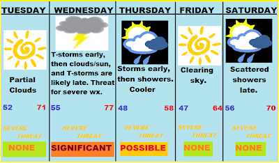
Anyway, have a good night! Nice, warm spring day tomorrow. I'm trying out a 5 day forecast, check it out below.

No comments:
Post a Comment