8:30PM EDIT
Thunderstorms are moving through KC with pea sized hail and non-severe wind gusts in some areas. The warm sector will remain south of KC and all severe weather will remain south of a Lyon Co. KS to Henry Co. MO line, well out of the Pleasant Hill NWS's warning area. As the low that you see in the surface map (below) moves northeastward, the warm front will begin to recede and the system should be taken over by the incoming cold front. Fortunately, this cold front shouldn't spark any severe weather, and temperatures behind the front aren't more than 5 or 10 degrees different than those here as we still are struggling to get above 52 or 53 degrees. Severe hail and wind gusts will be possible in far south and southeast KS, extreme southwest MO, far northwest AK, and, along with a continued risk for isolated strong and long-track tornadoes, through eastern OK into north central and northeast Texas. This activity will all be between the dry line (shown on the map in tan) and the warm front (in red) where the warm sector is promoting a very unstable environment, something we lack here, effectively eliminating all severe weather threat for Kansas City.
Thunderstorms are moving through KC with pea sized hail and non-severe wind gusts in some areas. The warm sector will remain south of KC and all severe weather will remain south of a Lyon Co. KS to Henry Co. MO line, well out of the Pleasant Hill NWS's warning area. As the low that you see in the surface map (below) moves northeastward, the warm front will begin to recede and the system should be taken over by the incoming cold front. Fortunately, this cold front shouldn't spark any severe weather, and temperatures behind the front aren't more than 5 or 10 degrees different than those here as we still are struggling to get above 52 or 53 degrees.
Severe hail and wind gusts will be possible in far south and southeast KS, extreme southwest MO, far northwest AK, and, along with a continued risk for isolated strong and long-track tornadoes, through eastern OK into north central and northeast Texas. This activity will all be between the dry line (shown on the map in tan) and the warm front (in red) where the warm sector is promoting a very unstable environment, something we lack here, effectively eliminating all severe weather threat for Kansas City.I'm already thinking ahead to tomorrow- warm air mass with mid 70-degree temperatures will feel great, and tomorrow night a few isolated thunderstorms may develop with a very slim chance for some of the storms to possibly reach severe limits, with hail and winds. Wednesday night into early in the day on Thursday will pose the next significant severe weather risk for KC. A warm sector is expected to overspread KC before a dryline approaches on Wednesday; a set up similar to today with more unstable air. Conditions won't be nearly as favorable for an extremely high tornado threat like today, but KC's first significant severe weather event for this spring may occur with isolated tornados possible. I'll update later tonight or tomorrow morning, once some newer model runs come out on Wednesday's threat. Tonight- just enjoy a nice, calming rain and look forward to some real spring weather tomorrow afternoon!
PREVIOUS ENTRY BELOW
*************************
Incredible number of large tornado reports in south KS through central OK. . . interestingly enough all but 5 or 6 of the numerous reports were in the moderate or slight risk area. The high risk continues to see a destructive tornado moving across its southern reaches, the same storm that caused a fatality in Norman and has had a strong, wedge tornado on the ground for more than an hour. The 2nd picture below is from KWTV OKC, showing the massive tornado in south OKC. Here in KC, the thunderstorms may enter the area before 9, with marginally severe hail the largest threat. Some recent model runs are suggesting increasing warmth into the KC region, however I believe the majority of this will stay well south of the metro. Right now, I think the chance of any severe weather here in KC is slim.
 Below is the tornado just north and east of Noble, Oklahoma on the southern side of Oklahoma City.
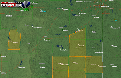
The final image below is of current warnings in the KC region, with Anderson and southern Franklin counties currently having severe thunderstorm warnings for quarter sized hail and maybe some gusty winds. Tornado threat for KC from this point on appears to be close to nothing- I'd be very surprised to see a tornado warning anywhere in EAX's CWA.

No comments:
Post a Comment