Initital damage surveys have indicated some of these tornados may have had wind speeds characteristic of upper-end EF3 tornados.
So for totals: about 10 different tornados were likely spotted yesterday. 42 total tornado reports, 49 severe wind reports, and 67 severe hail reports combined for a significant total of 158 preliminary severe weather reports.
As for tonight. . . the warm front will push to as far north as a Mound City, KS to Camdenton, MO. Along and ahead of this front, marginally unstable air, marked by CAPE values nearing 1500 j/kg, will push to the far southern reaches of the KC area. Any convection that can form will be elevated, and upper level winds appear to be at least somewhat supportive of a widely scattered marginally severe hail threat. This hail threat should stay south of KC, but some pea sized hail along with vivid lightning will be possible through tomorrow morning. By noon, the warm front should be near I70, and skies around KC may begin to clear. But here is where things get tricky- at some point tomorrow the warm front will clear I70, and we think it'll be around noon. But, this may happen earlier if tonight's LLJ can propel it into central MO faster. It may happen later if wind fields aren't supportive of frontal convergence or movement. Also, it could slow down if morning convection cools areas north of the front enough necessitating a higher concentration of the warm and moist airmass behind the warm front.
After it crosses the I70 corridor, it may drift gradually to the north but should stop well south of MO highway 36. Above the lower levels of the troposphere, a warmer air mass will be forced over the area, effectively capping the atmosphere until significant destablizing of the airmass can occur with convergence along the boundaries. Below is my best guess as to where the surface boundaries will set up tomorrow evening.

The low will be rapidly moving into far northeast KS by 7-8PM. By this time, KC should have reached 78-80 degrees in temperature, and close to 70 degrees in dew point. Below is the GFS temperature prediction for tomorrow evening.
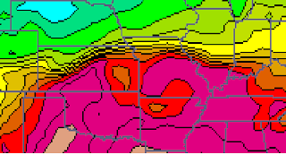
The deep red are temperatures in the upper 70s, and the first purple gradient is 80 degree temps. By tomorrow evening, the atmosphere should have destabilized creating a moderate to extremely turbulent atmosphere. The latest model compilations have pegged ML and MU capes between 3000 and 4000 j/kg for around this time. With the significant instability and pooling of warm, moist air concentration in the narrowing warm sector between the cold front and the warm front, some storms should be able to form and punch through the cap. Any storms that form in this saturated air mass will likely evolve to become severe within minutes of their formation. Areas along the warm front and along the cold front will have a small window when a potentially significant tornado threat may be posed. This is the area where highest helicity values will be present- storm relative helicity is one of the few inhibiting factors we have in this instance. Any areas of signficicant convergence should see helicity values rise into levels needed for surface based convection. Deep boundary layer moisture will further this threat along the fronts. Also, the closer to the low, the higher the risk of rotating storms. In this area, winds will be spinning more rapdily than other areas. So the set up is there for a potentially signficant, and somewhat widespread, severe thunderstorm and tornado outbreak across the area. But, there are some variables we are now uncertain on that will greatly sway tomorrow's threat.
1) Helicity values. Before 3 or 4PM, storm relative helicity values generally necessary for tornadic development will be very high. However, by the time convection can start to form, higher helicity readings appear to be retreating into Iowa and Nebraska. If convergence is strong enough coupled with the pooled moisture along the fronts and in the warm sector, we may see an isolated spike in helicity, which, right now, looks to have a good chance of happening. I'd go 60-40 that somewhere in the warm sector, close to the fronts and surface low, helicity values rise high enough to support surface rotation.
2) Warm front position and cloud cover. The warm front is forecast to move slightly north of KC by tomorrow evening. I'd say this seems very likely. But, KC's severe chances rest on the warm front's proximity to the metro. Areas along and just south of the front have the highest threat, and right now, if everything works out the way things are looking right now, it should be positioned north of KC. The farther away from KC, the lower our risk for any surface based storms. Also, a layer of low-based clouds may spread over KC late in the morning with some of the thunderstorms. If cloud cover can remain, my temperature prediction may not verify, especially if rain continues later into the afternoon than I am thinking it will. I would say that the chance of the warm front being positioned just north of KC isn't good, but it is our best prediction as of now. I'd say there's about a 60% chance that we'll adjust this frontal position north or south more than 40 miles in our future forecasts. I would also say that there's around a 30% chance that morning convection and clouds will inhibit instability.
3) Timing. Any tornado threat will be short lived. It should be focused around the extreme north section of the cold front near the low, and east along the warm front. Any slowing or speeding up of this system may change my timing predictions, although with every model release we are gaining confidence on the relative location of the cold front and surface low.
So, all in all, I'd say we have to watch this very closely. If things setup like their looking now, severe weather will be likely. But, the biggest question is how our tornado threat will shape up. If frontal convergence and moisture pooling occurs close to KC, or the atmosphere retains favorable helivity values, our threat will be greatly increased. But, as I pointed out above, this is very conditional and right now I don't have a significant amount of confidence in my prediction. Below, I've outlined where I think the best chances for severe weather will occur based on current trends, but remember to take this with a grain of salt. Or should i say many grains of salt? Uncertainty is high right now and there's a good chance models later tonight into tomorrow may greatly change my prediction. Regardless, it's a good idea to keep a NOAA weather radio around and an eye to the sky, to the forecast, and to local media for information on this rapidly evolving severe weather potential.
 I'll update later tonight or in the morning. So many questions in this forecast- I hope my analysis made some sense. Have a good night and keep an eye on the weather for tomorrow evening.
I'll update later tonight or in the morning. So many questions in this forecast- I hope my analysis made some sense. Have a good night and keep an eye on the weather for tomorrow evening.
No comments:
Post a Comment