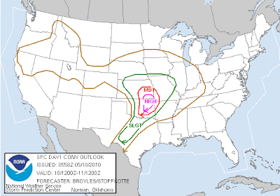
SPC 06Z outlook put out about 5 hours ago inserts a HIGH RISK over southeast KS and eat Oklahoma. Around that, a MODERATE RISK runs from Topeka southeast to Paola down to Joplin to southern Oklahoma. KC is on the edge of this, and the entire metro is in the 10% tornado/30% wind & hail slight risk area. Right now, wind profiles (helicity, shear) are more than favorable for a significant tornado event from east OK into the KC metro. However, the warm front, in the most recent model runs, appears to slow down, and unless the warm front passes through KC, bringing with it very moist and unstable air, our threat will be limited to elevated hail storms, with a potential wind threat if a bow echo can evolve. So while I am in general alignment with the SPC forecast, I believe this situation warrants extremely close watching for areas around the HIGH/MODERATE RISK areas, including KC. If saturated, warm tropical air can reach KC, our tornado threat will greatly increase. I urge you to pay close attention to the forecast for tonight. It appears the greatest window of opportunity exists from 8PM - 1AM in KC for any type of severe weather. Also, this morning, some marginally severe hail and gusty winds are possible with the showers and thunderstorms around the metro. I'll update later today. SPC outlook below.

No comments:
Post a Comment