 I'll update later if possible, but pay heed to NWS warnings and if reports continue to come in of 70-80MPH winds, it wouldn't be a bad idea to head to the lowest level and center part of your house. Remember, a severe thunderstorm warning doesn't indicate a lower danger than that contained within a tornado warning, it only indicates a different type of danger. Severe thunderstorms can produce winds that easily cause more damage than many tornadoes. Have a good and safe night everyone!
Saturday, June 19, 2010
More Storms Tonight
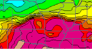
After a record breaking derecho tracked from eastern Nebraska all the way to Ohio yesterday we have been rocked with two significant thunderstorm events, one last night that produced storms to the north, and another coming in from the northwest earlier this afternoon which produced some scattered tree damage around the area with 60MPH+ winds. But, tonight, another bow echo (which is basically a line of thunderstorms with a bloated midsection indicating higher winds) is approaching from the west. It currently lies west of Topeka, but is packing potential 80MPH+ winds, and, as is always possible with bow echos, the chance for brief, but strong, spin-up tornadoes. We're under a severe thunderstorm watch until 3AM, and unless the thunderstorms weaken, we'll be in for a very significant event tonight. I didn't blog about the event earlier today for a number of reasons, one, it was a broken line, and, two, the reports weren't of extensive damage. I knew wind damage would be sparse, but tonight's situation may be a different story. Please take care to secure all outdoor furniture that could become debris in straight-line winds. Here is a graphic of the watch area: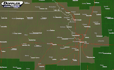 I'll update later if possible, but pay heed to NWS warnings and if reports continue to come in of 70-80MPH winds, it wouldn't be a bad idea to head to the lowest level and center part of your house. Remember, a severe thunderstorm warning doesn't indicate a lower danger than that contained within a tornado warning, it only indicates a different type of danger. Severe thunderstorms can produce winds that easily cause more damage than many tornadoes. Have a good and safe night everyone!
I'll update later if possible, but pay heed to NWS warnings and if reports continue to come in of 70-80MPH winds, it wouldn't be a bad idea to head to the lowest level and center part of your house. Remember, a severe thunderstorm warning doesn't indicate a lower danger than that contained within a tornado warning, it only indicates a different type of danger. Severe thunderstorms can produce winds that easily cause more damage than many tornadoes. Have a good and safe night everyone!
Friday, June 18, 2010
Tornadic Thunderstorms Up North
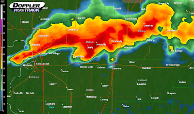
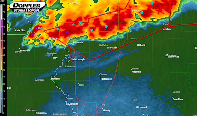
As of 11:15 PM the NWS has issued two severe thunderstorm warnings for parts of Daviess, Caldwell, Clinton, Andrew, Doniphan, Buchanan, and DeKalb counties after the tornado warning expired at 10:45. . . however the rotation still looks strong enough to me to easily produce a pretty strong, but quick, tornado, so if you have relatives up near Stewartsville, Osborn, Cameron, Amity, Maysville, and Clarksdale, let them know they should be keeping a close eye on this. Areas closer to St. Joseph have a much lower tornado threat but regardless of the tornado threat (funnels were spotted earlier near Union Hill) 70MPH straight-line winds and quarter-size hail stones are possible with these thunderstorms. This line of storms may hit KC within a couple of hours and may retain some of its strength, but right now I don't think it will, however it'd be a good idea to sleep with your weather radio on alert mode to warn you just in case. If anything major happens, I'll update, and have a good night everyone! Below is the NEXRAD image from 11:15.
 One last thing- the NWS, sensing the potential tornado threat, included this message in its latest warning text:
THIS IS A SUPERCELL THUNDERSTORM. DUE TO THE ROTATING NATURE OF THESE
STORMS...THEY ARE CAPABLE OF PRODUCING ALL TYPES OF SEVERE WEATHER...
INCLUDING EXTREMELY LARGE HAIL...DESTRUCTIVE STRAIGHT LINE WINDS AND
POSSIBLY TORNADOES. MOVE QUICKLY TO A SAFE SHELTER...PREFERABLY INTO
AN INTERIOR ROOM...SUCH AS A BATHROOM OR A CLOSET...OR INTO A
BASEMENT.
Sunday, June 13, 2010
Severe Thunderstoms Moving Into KC
 In the map above, the grayed in area is under a Severe Thunderstorm Watch. This will likely be extended eastward in the coming hours. These thunderstorms, which are now moving into Douglas county, will affect the entire KC region with damaging winds up to 70-80MPH, frequent cloud to ground lightning, small hail, and the potential for microbursts and brief spin up tornadoes, so it's a good idea to be in a safe place in your home as these move through.
Saturday, June 12, 2010
Flash Flooding is Likely Today
Flash Flood Warnings were issued across the metro this morning for the torrential rains produced by a morning MCS. Many locations received 2-4" of rain. This evening, thunderstorms should reform and it is very important to keep a close eye on Flash Flood Warnings, if and when they are issued. Here are some tips for flash flooding:
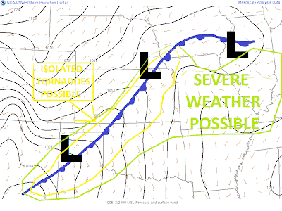
Also this evening is a slight risk of severe weather. Any thunderstorms that become particularly strong will have a risk of producing some isolated damaging winds and marginally severe hail. Shear and helicity are very low today for this area, so the chance of any tornadoes is close to none. But, we can't rule out the possibility of a weak tornado along the front. The map below shows the cold front, low pressure centers, and severe weather risks.
 So tonight, the main risk, and very deadly risk, is flash flooding. There is a limited threat for severe weather, and a near-zero risk for tornadoes. If anything changes, I'll post again later, but for now, enjoy the last couple of hours of warm temperatures, clear skies, and dryer air! I will mention that the dewpoints are climbing toward 75, so it is beginning to get humid. Have a nice evening!
- Never drive through flooded roadways unless it is an absolute must, and even then, only if the water is not flowing or is flowing slowly and is less than 6" in depth. If you cannot tell how high the water is, do not cross in any circumstances.
- Flooding is likely in any low lying areas. Make sure that pets, lawn furniture, balls, etc. are on higher land this evening. Water that isn't even up to the top of the grass can sweep many things away.
- Floods may reach your house. If so, do not exit unless critical for your safety, remove the power source from any exterior electronics and electrical plugs, and put sandbags around your doors if possible.
Also this evening is a slight risk of severe weather. Any thunderstorms that become particularly strong will have a risk of producing some isolated damaging winds and marginally severe hail. Shear and helicity are very low today for this area, so the chance of any tornadoes is close to none. But, we can't rule out the possibility of a weak tornado along the front. The map below shows the cold front, low pressure centers, and severe weather risks.
 So tonight, the main risk, and very deadly risk, is flash flooding. There is a limited threat for severe weather, and a near-zero risk for tornadoes. If anything changes, I'll post again later, but for now, enjoy the last couple of hours of warm temperatures, clear skies, and dryer air! I will mention that the dewpoints are climbing toward 75, so it is beginning to get humid. Have a nice evening!
Tuesday, June 8, 2010
Tornado Watch
4:40PM UPDATE
Severe thunderstorm warnings are now being issued across the tornado watch. Here's a radar image from 4:40 of the supercell south of KC near Spring Hill. This thunderstorm can produce 70MPH winds and baseball sized hail. Some rotation has been observed, so pay close eye to all future warnings. Keep a weather radio close by tonight!
 PREVIOUS ENTRY BELOW
-------------------------------
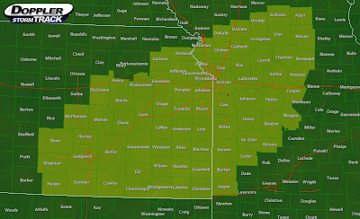
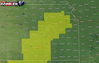
Most of the area is now under Tornado Watch #285 effective until 9PM tonight. The counties in the watch are highlighted in yellow in the image below.
 Conditions are favorable for, possibly, our biggest severe weather event of the year. Isolated tornadoes, very large hail, and wind gusts are likely with the thunderstorms that, as of right now, are rapidly developing and intensifying. None of the thunderstorms are severe right now, but are dropping torrential rains with 1" per hour rainfall rates. Flash flooding is a major concern, especially in northern Missouri. Remember, do not cross roadways that are covered by water. 6" of water can sweep a car away. I'll update in a few minutes.
Severe thunderstorm warnings are now being issued across the tornado watch. Here's a radar image from 4:40 of the supercell south of KC near Spring Hill. This thunderstorm can produce 70MPH winds and baseball sized hail. Some rotation has been observed, so pay close eye to all future warnings. Keep a weather radio close by tonight!
 PREVIOUS ENTRY BELOW
-------------------------------
Most of the area is now under Tornado Watch #285 effective until 9PM tonight. The counties in the watch are highlighted in yellow in the image below.
 Conditions are favorable for, possibly, our biggest severe weather event of the year. Isolated tornadoes, very large hail, and wind gusts are likely with the thunderstorms that, as of right now, are rapidly developing and intensifying. None of the thunderstorms are severe right now, but are dropping torrential rains with 1" per hour rainfall rates. Flash flooding is a major concern, especially in northern Missouri. Remember, do not cross roadways that are covered by water. 6" of water can sweep a car away. I'll update in a few minutes.
Severe Thunderstorm Watch
8:00AM UPDATE
Alright, this is just a quick update that the storms are making there way into the KC area, and they have weakened below severe limits. Lots of lighting, heavy rain, a wind gust or too, and maybe some pea sized hail in some places is possible with these thunderstorms. I'll update in a few hours on tonight's severe potential.
PREVIOUS ENTRY(S) BELOW
-------------------------------
The SPC has issued Severe Thunderstorm Watch 284 effective immediately and expiring at 9AM CDT for portions of the KC area, from the 2nd tier of counties in eastern KS to points westward into central KS. A map with the watch regions highlighted is below. You can also see the radar picking up the leading edge of a bow-echo in north central KS and southern NE. These storms are very strong, packing winds up to 70MPH, and some gusts may be even higher.
 If this bow echo holds together and retains the strong winds, it should pull through KC around 8AM this morning with the possibility for severe winds. I have relatively high confidence in the timing of these thunderstorms that are associated with an MCS, or mesoscale convective system, which is simply a large mass of thunderstorms all behaving in a similar fashion, and moving in a similar direction.
As for the rest of tomorrow, below is my revised version of the SPC Day 1 outlook. I believe that tomorrow afternoon, more severe thunderstorms will develop along or just north of I-70, and that they'll push southward with large hail, damaging wind, and possibly a couple of isolated tornadoes. I'm not sure how readable my text is there, so sorry for that. But, what it contains is reference to my forecast that the highest tornado threat will be confined to along and just south of the front, which may set up anywhere from north central MO to just south of KC. Right now, my best guess and the best guess of the NWS using the NAM model is that the front will set up along I-70 and stretch northeast into IL.
For tonight's storms, around 8AM you can expect some thunder around, severe weather possible so keep a weather radio on if you won't be up by then. I think that the storms may weaken, but we'll just have to see. Have a great night everyone! And, I'll update before 8AM if the storms continue to be severe.
Alright, this is just a quick update that the storms are making there way into the KC area, and they have weakened below severe limits. Lots of lighting, heavy rain, a wind gust or too, and maybe some pea sized hail in some places is possible with these thunderstorms. I'll update in a few hours on tonight's severe potential.
PREVIOUS ENTRY(S) BELOW
-------------------------------
The SPC has issued Severe Thunderstorm Watch 284 effective immediately and expiring at 9AM CDT for portions of the KC area, from the 2nd tier of counties in eastern KS to points westward into central KS. A map with the watch regions highlighted is below. You can also see the radar picking up the leading edge of a bow-echo in north central KS and southern NE. These storms are very strong, packing winds up to 70MPH, and some gusts may be even higher.
 If this bow echo holds together and retains the strong winds, it should pull through KC around 8AM this morning with the possibility for severe winds. I have relatively high confidence in the timing of these thunderstorms that are associated with an MCS, or mesoscale convective system, which is simply a large mass of thunderstorms all behaving in a similar fashion, and moving in a similar direction.
As for the rest of tomorrow, below is my revised version of the SPC Day 1 outlook. I believe that tomorrow afternoon, more severe thunderstorms will develop along or just north of I-70, and that they'll push southward with large hail, damaging wind, and possibly a couple of isolated tornadoes.
 I'm not sure how readable my text is there, so sorry for that. But, what it contains is reference to my forecast that the highest tornado threat will be confined to along and just south of the front, which may set up anywhere from north central MO to just south of KC. Right now, my best guess and the best guess of the NWS using the NAM model is that the front will set up along I-70 and stretch northeast into IL.
For tonight's storms, around 8AM you can expect some thunder around, severe weather possible so keep a weather radio on if you won't be up by then. I think that the storms may weaken, but we'll just have to see. Have a great night everyone! And, I'll update before 8AM if the storms continue to be severe.
Monday, June 7, 2010
Severe Weather Potential. . . Tonight and Tomorrow
12:15 AM UPDATE
The MCS has developed and is moving much more to the south now than previously projected by any forecasters. This mass of thunderstorms has triggered a bow echo in central Nebraska that is moving toward Hastings and will push into north-central and northeastern KS later this morning (probably near dawn or slightly earlier). This is very important in tracking severe weather, as our atmosphere is modestly unstable, and if the bow echo holds together, we may see some damaging winds as this moves into NW and west-central Missouri. I still think it will exit in time for more afternoon storms tomorrow. I'll update later. Thanks for checking in!
PREVIOUS ENTRY BELOW
-------------------------------------
 The next image is the reflectivity from the same time, with an arrow and a circle placed into and around the area where the tornado is likely forming. The line indicates the inflow into the thunderstorm. This is a classic example of a 'hook echo' with a supercell.
 These thunderstorms will likely form into an 'MCS', or 'mesoscale convective system'. They are very far north and west of KC- nearly 400 miles away. They will near our region very late tonight into early tomorrow morning, and may even affect going to work traffic. Northern Missouri has the best threat to see any thunderstorms, mainly north of Highway 36. As they continue on their path, they might dip into the area, but right now I somewhat doubt the contact of the MCS with Kansas City. For the high, I'm thinking we'll reach 90-95 if, and only if, the MCS doesn't come into contact with KC and we are able to clear the clouds out bringing us sun and daytime heating. If we do have rain and thunderstorms tomorrow, mainly in the morning to late morning, we may only get up to 85 or so, and that high may come before the MCS reaches KC. If the MCS does impact KC, strong wind gusts and maybe some large hail would be the threats. But, if we have time to heat up tomorrow, then the main threat would be later in the afternoon as the warm front/cold front approaches KC. These thunderstorms would likely be very severe, with very large hail and damaging winds the greatest threats, although we may have a few tornadoes, especially along and just south of the front which is forecast to be near I-70. However, the tornado threat is still relatively low. I'll update if I get new model data, but enjoy a few quiet hours and be ready for storms tomorrow!
And a quick note to anyone in northern MO- heavy rain is likely with this MCS, maybe on the scale of up to 3". Flash flooding is likely in these areas, so remember to avoid low lying areas, and to never drive across water-covered roadways. Pay close attention to NWS Flash Flood Warnings.
Tuesday, June 1, 2010
June 1st
10:00PM UPDATE
Severe thunderstorm warnings have been issued for this entire line of thunderstorms north of KC. Here is a Level III NEXRAD image from 10:00PM with the warned areas indicated by the red polygons:
 These are very intense thunderstorms but there are some signs that they may be weakening. A 90MPH wind gust was reported with these storms earlier. I still expect these storms to weaken as they push southeast and I believe that they'll impact KC with heavy rain, winds, and hail all below severe levels. I'll update tonight if things change, but if you live north of the metro, please keep a close eye on these thunderstorms. While the tornado threat remains very, very low, a damaging wind threat appears possible for at least another hour. Remember that damaging winds can and do cause damage just as expansive as that caused by tornadoes.
PREVIOUS ENTRY BELOW
**************************
It's June! School's out and warm weather is in- 90 degrees and higher in the sun in most locations this week. But, when it's not warm and muggy thunderstorms seem to be popping up, and strong storms formed in JOCO earlier today prompting a severe thunderstorm warning and triggering some marginally severe hail near Olathe- along with some strong wind gusts and heavy rain. But, for tonight, there is a threat of some thunderstorms (possibly severe) in and around the KC area. Here's a view of the NEXRAD image from 9:15PM this evening: Gentry, Harrison, and Worth counties in northern MO are currently under severe thunderstorm warnings. As this is very time sensitive, by the time anyone reads this the warnings will most likely have moved on. The greatest threat with any of these storms will be nickel sized hail and very strong winds, possibly pushing 70MPH in the most dangerous severe thunderstorms tonight. By about midnight, most of us here in KC should start to hear thunder in the distance and maybe see some lightning. 2AM and later is when we can expect to see any thunderstorms-pea size hail and gusty non-severe winds are possible. Heavy rains, maybe a flooding threat in low-lying areas, will also be likely. For a specific severe threat, I'd have to say that KC's threat is extremely low, and by midnight, most of the mid- and upper-level winds, along with the LLJ (low level jet) will have relaxed enough to diminish the severe threat. Before midnight, areas in northern Missouri will continue to have an isolated severe wind threat.
Tomorrow's forecast is incredibly difficult- the front that is accompanying these severe thunderstorms will stall (and disintegrate) across the area tomorrow morning, and after some early thunderstorms, another 80-90 degree day is likely. By afternoon, the weakening stalled front may (will) provide a focus area for thunderstorm development. Wind shear numbers aren't looking great, but instability is looking rather extreme, and any variation in wind shear forecasts could really spike a severe weather forecast. For now, I'd say marginally severe hail and strong winds will be likely with any thunderstorms tomorrow afternoon. If some of the atmospheric wind profiles can pick up a little bit, we may see a higher severe hail threat, and maybe the potential for an isolated tornado or two in the region, but right now winds aren't looking very supportive of a tornado threat.
For the weekend, the jet stream will sag southward and set up a very strong upper level wind force above the KC area, and will allow any surface lows and disturbances to ride this very powerful stream across the area. So, any SFC lows that move towards the area from Saturday through next Wednesday will need to be watched very closely for an increased hail and tornado threat. By June 15th, the tornado threat for our area will be over, and the rest of the summer should be marked by classic summer thunderstorms. I'll keep this updated the next few days, but enjoy some comfortable weather in the shade, and keep an eye to the sky through tomorrow, and this weekend.
Severe thunderstorm warnings have been issued for this entire line of thunderstorms north of KC. Here is a Level III NEXRAD image from 10:00PM with the warned areas indicated by the red polygons:
 These are very intense thunderstorms but there are some signs that they may be weakening. A 90MPH wind gust was reported with these storms earlier. I still expect these storms to weaken as they push southeast and I believe that they'll impact KC with heavy rain, winds, and hail all below severe levels. I'll update tonight if things change, but if you live north of the metro, please keep a close eye on these thunderstorms. While the tornado threat remains very, very low, a damaging wind threat appears possible for at least another hour. Remember that damaging winds can and do cause damage just as expansive as that caused by tornadoes.
PREVIOUS ENTRY BELOW
**************************
It's June! School's out and warm weather is in- 90 degrees and higher in the sun in most locations this week. But, when it's not warm and muggy thunderstorms seem to be popping up, and strong storms formed in JOCO earlier today prompting a severe thunderstorm warning and triggering some marginally severe hail near Olathe- along with some strong wind gusts and heavy rain. But, for tonight, there is a threat of some thunderstorms (possibly severe) in and around the KC area. Here's a view of the NEXRAD image from 9:15PM this evening:
 Gentry, Harrison, and Worth counties in northern MO are currently under severe thunderstorm warnings. As this is very time sensitive, by the time anyone reads this the warnings will most likely have moved on. The greatest threat with any of these storms will be nickel sized hail and very strong winds, possibly pushing 70MPH in the most dangerous severe thunderstorms tonight. By about midnight, most of us here in KC should start to hear thunder in the distance and maybe see some lightning. 2AM and later is when we can expect to see any thunderstorms-pea size hail and gusty non-severe winds are possible. Heavy rains, maybe a flooding threat in low-lying areas, will also be likely. For a specific severe threat, I'd have to say that KC's threat is extremely low, and by midnight, most of the mid- and upper-level winds, along with the LLJ (low level jet) will have relaxed enough to diminish the severe threat. Before midnight, areas in northern Missouri will continue to have an isolated severe wind threat.
Tomorrow's forecast is incredibly difficult- the front that is accompanying these severe thunderstorms will stall (and disintegrate) across the area tomorrow morning, and after some early thunderstorms, another 80-90 degree day is likely. By afternoon, the weakening stalled front may (will) provide a focus area for thunderstorm development. Wind shear numbers aren't looking great, but instability is looking rather extreme, and any variation in wind shear forecasts could really spike a severe weather forecast. For now, I'd say marginally severe hail and strong winds will be likely with any thunderstorms tomorrow afternoon. If some of the atmospheric wind profiles can pick up a little bit, we may see a higher severe hail threat, and maybe the potential for an isolated tornado or two in the region, but right now winds aren't looking very supportive of a tornado threat.
For the weekend, the jet stream will sag southward and set up a very strong upper level wind force above the KC area, and will allow any surface lows and disturbances to ride this very powerful stream across the area. So, any SFC lows that move towards the area from Saturday through next Wednesday will need to be watched very closely for an increased hail and tornado threat. By June 15th, the tornado threat for our area will be over, and the rest of the summer should be marked by classic summer thunderstorms. I'll keep this updated the next few days, but enjoy some comfortable weather in the shade, and keep an eye to the sky through tomorrow, and this weekend.
Sunday, May 23, 2010
Warmer Weather!
Alright, sorry for the really long wait for this blog. . . but the last week has been ridiculously busy, and with finals starting tomorrow, it'll probably be that way for a couple more days. But, right now, I'm taking a break from some of the studying to finally get to discuss the severe weather and bow echo from a couple of weeks ago, and to mention the tornadoes that happened a few days ago around Warrensburg and Sedalia.
Below is the Level II NEXRAD image from 11:36 on that Thursday night, with arrows drawn in depicting wind flow into and out of the line of thunder
storms.
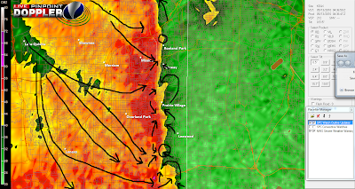
The city in the center of the image is Prairie Village,
with Leawood just to the southeast. I drew in all the rear inflow jet locations (those are the north to south or northwest to southeast arrow) with black. The rear inflow jet is an area of enhanced windflow into the thunderstorm, and, when coupled with enhanced windflow into the thunderstorm from the opposite direction, can lead to 'mesovortices'. Mesovortices are common with bow echo thunderstorms, and are what led to the EF-2 and EF-3 tornadoes in the northland last year. In bow echoes, when shear
and helicity values are high enough, any interaction between the west-east winds of the bow echo and the winds of another thunderstorm, or of a frontal boundary, can trigger the thunderstorm to start rotating, pulling in air from behind (the rear inflow jet) and wrapping winds from the south into the thunderstorm (indicated by the black arrows that move in a curved line generally to the northwest). When this happened, the change in wind profiles are picked up by doppler radar, and small 'hooks' or notches can form on the radar. These are extremely small areas where wind convergence from the bow echo and another atmospheric convective feature is strong enough to produce a brief (but usually strong) circulation. NEXRAD picked up on this and indicated NRO
T (Normalized ROTation) values close to or exceeding '1' around this time, which is typically the threshold where a tornado appears possible. But sometimes, in bow echoes, the west to east winds are so strong that, while a brief circulation is attained with interaction with another convective feature, the winds are only strengthened or pushed closer to the ground, which can often lead to intense downbursts, which are usually localized and known as 'microbursts'. Microbursts cause tornado-like damage, last for only a few minutes or less, and on radar can be hard to discern from tornadoes in severe weather situations. What happened on Thursday, I believe, was a situation where two very small but intense microbursts sent 70MPH+ winds roaring through parts of Olathe and Gardner, indicated by the damage in small areas. Also, the damage was in a relatively straight line. Tor
nado damage is generally very strewn about and sometimes a circular pattern is apparent. This was obviously not the case. But, in DeSoto, where a barn was destroyed, but the houses around virtually untouched, one would have to think that the possibility of a microburst was relatively small considering the microscopic range
of the winds and damage. A localized straight line wind gust or tornado may have been responsible. In bow echoes, when tornadoes do form, they typically only remain on the ground for a few seconds at the most, causing little or no damage to 1 or 2 structures, which I think was very possible in this area.
Below is the radar image with windflow drawn in around the time the damage was reported in JOCO. A notch is visible in the radar just to the northeast of DeSoto.
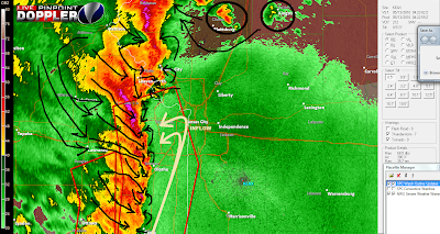
Any of these 'mesovortices', which are indicated when two areas are pointing nearly directly at each other, have the potential to produce a brief but strong downburst, wind gust, funnel cloud, or tornado. I was watching this very closely of course, and as the storms approached NE JOCO, where I live, I continued to notice the mesovortices and lack of proper warning by media outlets.
Regardless of the type of severe weather occuring, be it tornado or damaging winds, the storm produced damage that was severe enough to be considered life-threatening, and so I think that local media have a responsibility to cover situations like this.
But back to the mesovortices. . . as the storm approached my home, my ears suddenly popped and I heard a loud whooshing sound, I looked outside, and the wind was blowing stronger than I think I've ever seen it, even in a thunderstorm. My ears continued to hurt, and I took shelter downstairs, but the winds subsided within 30 seconds. The next morning, no damage was to be seen. So what happened? Well, first of all, straight-line winds don't normally produce a 'whooshing' sound unless the winds are strong enough to cause severe structural damage. But, funnel clouds can trigger ground pressure changes (i.e. ear popping) and a whooshing sound near by them. While I don't believe the circulation reached the ground, the already gusty winds of the storm may have created a tornado-like scene outside, which is what I saw. Even so, I believe there were probably numerous funnels over head, something most of us couldn't see because of how late at night it was.
So, in conclusion, a mix of severe weather probably occurred. And, tornado-like damage was the result of these dangerous storms. So the message is to take shelter whenever you hear a severe thunderstorm OR tornado warning has been issued. Severe thunderstorms can produce just as much damage as tornadoes but are often not covered as extensively as tornadoes because severe thunderstorms don't carry the connotation that they are highly damaging. I hope all of this made sense, and please share your thoughts!
Anyway, onto the other day near Sedalia. The surface low and front was located nearby, creating ample shear for any surface based storms that formed in the stable environment to produce brief and weak tornadoes, which is what happened. NROT values never indicated a tornado vortex signature or mesocyclone, because of the extremely brief and weak natures of these storms. Luckily, no significant damage was reported and most of the time the storms were in unpopulated areas, but did get frighteningly close to Sedalia.
As for this week- FINALLY! It's hit 80 degrees! And, every day this week we should exceed the 80 degree mark. We might even reach 90 one day this week if the saturated grounds can have some of their water evaporate. A deep ridge has built in over the west, keeping all storm systems well away from KC, and an area of very high pressure has set in. However, if for some odd reason, diurnal surface storms pop up in an extremely scattered fashion, they will warrant some watching as instability is high and marginally severe weather would be possible. But, for the most part, I think this week should be dry and hot! No significant severe weather, but looking at the extended GFS I see at least one. . . maybe two more severe weather days for KC this year, some of which might be more widespread than our prior attempts this year, as warmer air is finally surging in. The earliest chance for any storms is more than a week away, so enjoy the warm air, and make sure to drink plenty of water and wear sunscreen if you're going to be spending a lot of time outside to prevent heat exhaustion and sunburn. Have a great week!
Friday, May 14, 2010
Theory. . .
It's been two days since my last post. . . sorry for the wait! In the mean time, I've studied some damage and damage photos from the storms, along with reviewing radar data, and reading some research papers and AMS reports on 'mesovorticies' in bow echoes, and have come to a consensus on what likely happened late Wednesday night in JOCO. I'll try to post this tomorrow- I've been really busy! In the mean time, enjoy some non-severe thunderstorms this weekend with modest temperatures. Hopefully most of tomorrow will be dry!
Wednesday, May 12, 2010
Thunderstorms Rapidly Intensifying. . .
12:24 AM UPDATE
After having a little panic attack there (haha), I'm beginning to analyze what happened, and what may still be happening, however I think the bow echo is now, truly, just that- strong, straight line winds. As it intensified east of Topeka, it absorbed many atmospheric disturbances. . . remnants of thunderstorms from earlier today, existing showers, heating from the surface, etc. Riding the cold front, it's easterly movement with winds from the west, and our winds from the south with the passage of the warm front earlier directly contrasted with each other. This created a situation where small, brief tornados could easily develop with any environmental trigger. . . like some of the existing low level clouds and showers over JOCO/Wyandotte from earlier. With the wind contrast and the surface disturbance, shear likely increased, and the updraft-veritcle rotation situation that occured allowed for a brief but scary spin up of a torando, possibly in numerous location. Many damage reports have come from JOCO in the last hour, with 'microburst' type damage, power outages, trees through houses, windows out. . . I've talked to a few people from my area in northeast JOCO who heard the same 'train roar' or loud 'whoosh' noise, something generally assosciated with tornados- especially the pressure drop evidenced by ears popping. So, while these tornados (if they were, remember this is not confirmed) were brief, they were potentially strong. Straight-line winds usually don't blow out windows and send trees through the house. . . they can do quite a bit of damage but that's a stretch. A microburst is possible, but downdrafts indicated a brief tornado threat was more likely. I mentioned this threat before the bow echo came through KC, and obviously it did cause some issues. . . many areas of rotation, many small spin ups likely happened. We'll know in the morning.
For the rest of the night. . . this line of strong thunderstorms will affect central and eastern Missouri, but is currently below severe limits and will likely stay that way. Penny sized hail and 50 mph wind gusts are possible.
More storms are moving up I35 from Emporia towards KC, these too could produce gusty winds and penny sized hail. Right now, I don't believe they will intensify, as our environment is more stable with the passing of the cold front. If something changes, I'll let you know. Flooding will continue to be a threat tonight into tomorrow morning.
This was an interesting night. . . I'll discuss it more tomorrow. Have a good, safe night everyone!
PREVIOUS ENTRY BELOW
************************
I went ahead and deleted this portion of the blog as it contained mostly time-sensitive information about warnings.
Severe Weather Update
10:30 PM UPDATE
The line of thunderstorms (none currently severe warned) out to our west by 1 or 2 hours is beginning to bow out, showing signs that some of the winds on the leading edge of these storms is meeting or exceeding severe limits, and a parts of the line have exhibited signs of brief lower-level rotation when they overtook other, smaller, thunderstorms. These may become severe warned with a risk for up to 60-70 mph winds, and a very, very, slight chance for an isolated tornado-
and, well mid-blog the NWS in Pleasant Hill has issued a SEVERE THUNDERSTORM WARNING for Leavenworth and southeast Atchison counties in KS and western Platte county in Missouri until 11:15 PM.
The latest velocity scan out of the Topeka NEXRAD is indicating surface winds pushing 70 mph. Also, the latest scans have indicated a strengthening surface rotation couplet south of Lawrence. I'll watch these storms for the next half an hour or so and update on any new developments.
PREVIOUS ENTRY BELOW
*************************
All severe thunderstorms in the area have weakened. Flash flood warnings remain in effect for most of the metro until 5:30 AM tomorrow. The tornado watch will expire at midnight along with the severe thunderstorm watch. With the warm front barely clearing KC and strong capping, the severe threat didn't get as dangerous as it could have been. While our thunderstorm outlooks varified (statistically speaking), the situation didn't end up being quite as dangerous as it could have been. For the rest of the night, flooding, which is the #1 cause of weather-related death in the U.S. will be the main threat. Lots of lightning and the potential for some pea size hail to marginally severe quarter sized hail in the stronger storms should be the extent of the remaining threat tonight. A severe thunderstorm watch may replace the current watches across the area at midnight. I'll update if anything very significant materializes- but right now I don't think there's much of a tornado or damaging wind threat tonight. Tomrrow will be much cooler (most of the day in the 50s!) and rainy through the morning. We'll summarize the severe weather reports from today tomorrow evening. Have a good night!
Thunderstorms Forming. . . Outlook Update
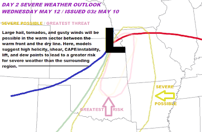
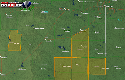
Funnels have already been reported over central KS, near Hutchinson, and a tornado has just been confirmed on the ground northeast of the city, near McPherson. Multiple tornado warnings and numerous severe thunderstorm warnings are in effect for the western portions of Tornado Watch #155 (which includes Jefferson and Douglas Co. in Kansas). These thunderstorms are primarily linear but have embedded supercellular structures allowing for a significant tornado threat with these thunderstorms. The warm front is moving through the KC area right now, with temperatures in JOCO in the upper 70s, but only 61 at MCI Airport. Clouds have held over KC but instability is growing with the advancement of the warm front. A relatively strong cap is holding in the atmosphere over KC, but has already been broken just west of Wichita. This has led me to shift my 'Greatest Risk' area to the southwest, and I've left KC out of that outlook region. I believe the highest tornado threat will be well southwest of KC today, with atmospheric conditions becoming more probably there with the already unstable and saturated environment. I've included KC in the 'Likely' area because of a significant threat for large, damaging hail, and isolated tornados. Farther to the north and east, large hail will still be possible, in some of the stronger storms ahead of the warm front. That is why I've kept those locations in the 'Possible' area for severe weather. As for here in KC, please continue to monitor this situation as the situation in southern Kansas is quickly involving into a significant severe weather event. Large, damaging hail will be the greatest threat with any of these storms. I've posted my updated outlook for tonight along with a tornado watch graphic below. I'll update later on.

Tuesday, May 11, 2010
Latest Model Trends
The 00z NAM has been released, and SREF parameters have been updated. Confidence is increasing in this event for tomorrow. Alot of the questions that I posed in my previous post are somewhat clearer. I have great confidence that KC will hit 80 degrees tomorrow. The dew point will rapidly climb to nearly 70 degrees in the afternoon. The latest models show sufficient helicity along the surface boundaries to support surface supercells. The cap should be broken in the afternoon/evening because of extreme forcing. Instability will be very high- the atmosphere will rapidly destabalize in the afternoon leading to ML and MU CAPE >3000 j/kg. The LLJ should intensify and combine with existing shear in the atmosphere to allow for a small window of potentially significant tornado threat. The latest supercell composite, which maxes out at 12, has the entire region in that '12'. Supercells are very likely. Surface based supercells should also form early on in convective development near the surface boundaries in the saturated warm sector. This means that from Lawrence. . . to St. Joseph. . . to Kirksville. . . to Marshall. . . to Ottawa. . . and back to Lawrence, a region will emerge where a potentially volatile tornado situation could take shape sometime in the late afternoon tomorrow. 5PM-8PM is my best guess. We now begin to nowcast. . . and make forecasts based on current surface observations.
For tonight, strong thunderstorms are developing south of an Iola to Clinton line. Pea sized hail and vivid lightning is likely with this storms. I don't think these storms will result in any severe weather threat.
For tomorrow, here are my main points:
- Before 12PM- showers and thunderstorms around, moving to the north. Pea sized hail, gusty winds, and lightning are likely. Severe hail isn't out of the question but is becoming increasingly less likely.
- 12PM-5PM- skies will clear out and temperatures will climb to around 80 degrees, with an extremely humid summer-like airmass in the city. Clouds may start to build toward the end of this period. Pay close attention to forecasts for later in the night.
- 5PM-10PM-Our confidence in a SIGNIFICANT SEVERE WEATHER EVENT for KC is growing with each model trend. During this time, destructive hail, severe wind gusts, and tornados will be possible with any storms that develop. Make sure you stay up-to-date with the latest forecast information. Also, ensure that you and/or your family have a severe weather plan ready to be implimented should a tornado and/or severe thunderstorm warning be issued for your area.
- 10PM and on-Another round of severe weather is possible as the cold front moves through. Very large hail and damaging winds are possible, especially if a bow echo can form. The tornado threat is relatively low with these storms, but the formation of a couple of brief tornados is not all that rare on the leading edge of a bow echo.
My updated outlook is below. Remember, things still can change, but let's hope for the best, and prepare for the worst. Have a good night everyone, keep in mind tomorrow will feel so much better than all these cold days we've been having- and, the severe risk, while significant, should only last a few hours in the evening.
A Recap of Yesterday and Model Trends
Let's take a look back at what happened yesterday. An unusually moist, but cool, airmass surged northward into northeast Texas, Oklahoma, and extreme southeast Kansas. A very well defined dry line pushed eastward extending south from a surface low in south central Kansas. Shear and helicity values were off the charts. CAPE was nearing or exceeding 3000 j/kg (indicating extreme instability). Shortly after noon, isolated thunderstorms produced a couple of tornadoes in far west Kansas, prompting the SPC to expand their moderate risk westward- something that would soon prove to be an excellent idea. By 2-3PM, storms fired along the dryline in north central Oklahoma and south central Kansas. These storms became tornadic in well under an hour, producing multiple large wedge tornados. One tracked from near Enid to well east of I35. Another moved from near the OK/KS border into Arkansas City, producing damage. It continued to move rapidly to the northeat with periodic tornado reports continuing. Wichita was tornado warned for quite some time, and tornados were reported around Mid-Continent airports, however no damage was reported in Wichita's city limits. Farther south, disorganized convection formed near OKC and quickly became surface based, dropping a few tornados in and around the city. The most significant of these formed on the south side of the city of Norman. KWTV captured the massive funnel as it touched down and destroyed nearly 50 houses, damaged many more, and, tragically, caused a few fatalities. This tornado remained on the ground for an unknown amount of time- reports of a tornado came in until around 9PM but it is unknown whether this was one or multiple tornados. Most likely, this storm produced 5 to 6 tornados, with 2 or 3 being large and destructive. In southern Oklahoma, multiple tornados, including one large wedge tornado, were reported in the Ardmore vicinity. As I said earlier, the SPC is lucky to have extended the moderate risk westward. The bulk of the tornados occured either in the moderate or slight risk areas. The well publicized high risk area saw only 3 tornados, all on it's edge. The Arkansas City and Enid tornados moved into the extreme western portion of the risk area, and the massive long-track OKC tornado skirted highway 44 on the southern edge of the risk. So, overall, it was an excellent chase day. Amazing data has been collected and there are many beautiful pictures. However, this day will best be remembered for the tragic fatalities of at least 5 Oklahoma residents who lost their lives to these massive twisters.

Initital damage surveys have indicated some of these tornados may have had wind speeds characteristic of upper-end EF3 tornados.
So for totals: about 10 different tornados were likely spotted yesterday. 42 total tornado reports, 49 severe wind reports, and 67 severe hail reports combined for a significant total of 158 preliminary severe weather reports.
As for tonight. . . the warm front will push to as far north as a Mound City, KS to Camdenton, MO. Along and ahead of this front, marginally unstable air, marked by CAPE values nearing 1500 j/kg, will push to the far southern reaches of the KC area. Any convection that can form will be elevated, and upper level winds appear to be at least somewhat supportive of a widely scattered marginally severe hail threat. This hail threat should stay south of KC, but some pea sized hail along with vivid lightning will be possible through tomorrow morning. By noon, the warm front should be near I70, and skies around KC may begin to clear. But here is where things get tricky- at some point tomorrow the warm front will clear I70, and we think it'll be around noon. But, this may happen earlier if tonight's LLJ can propel it into central MO faster. It may happen later if wind fields aren't supportive of frontal convergence or movement. Also, it could slow down if morning convection cools areas north of the front enough necessitating a higher concentration of the warm and moist airmass behind the warm front.
After it crosses the I70 corridor, it may drift gradually to the north but should stop well south of MO highway 36. Above the lower levels of the troposphere, a warmer air mass will be forced over the area, effectively capping the atmosphere until significant destablizing of the airmass can occur with convergence along the boundaries. Below is my best guess as to where the surface boundaries will set up tomorrow evening.
The low will be rapidly moving into far northeast KS by 7-8PM. By this time, KC should have reached 78-80 degrees in temperature, and close to 70 degrees in dew point. Below is the GFS temperature prediction for tomorrow evening.
The deep red are temperatures in the upper 70s, and the first purple gradient is 80 degree temps. By tomorrow evening, the atmosphere should have destabilized creating a moderate to extremely turbulent atmosphere. The latest model compilations have pegged ML and MU capes between 3000 and 4000 j/kg for around this time. With the significant instability and pooling of warm, moist air concentration in the narrowing warm sector between the cold front and the warm front, some storms should be able to form and punch through the cap. Any storms that form in this saturated air mass will likely evolve to become severe within minutes of their formation. Areas along the warm front and along the cold front will have a small window when a potentially significant tornado threat may be posed. This is the area where highest helicity values will be present- storm relative helicity is one of the few inhibiting factors we have in this instance. Any areas of signficicant convergence should see helicity values rise into levels needed for surface based convection. Deep boundary layer moisture will further this threat along the fronts. Also, the closer to the low, the higher the risk of rotating storms. In this area, winds will be spinning more rapdily than other areas. So the set up is there for a potentially signficant, and somewhat widespread, severe thunderstorm and tornado outbreak across the area. But, there are some variables we are now uncertain on that will greatly sway tomorrow's threat.
1) Helicity values. Before 3 or 4PM, storm relative helicity values generally necessary for tornadic development will be very high. However, by the time convection can start to form, higher helicity readings appear to be retreating into Iowa and Nebraska. If convergence is strong enough coupled with the pooled moisture along the fronts and in the warm sector, we may see an isolated spike in helicity, which, right now, looks to have a good chance of happening. I'd go 60-40 that somewhere in the warm sector, close to the fronts and surface low, helicity values rise high enough to support surface rotation.
2) Warm front position and cloud cover. The warm front is forecast to move slightly north of KC by tomorrow evening. I'd say this seems very likely. But, KC's severe chances rest on the warm front's proximity to the metro. Areas along and just south of the front have the highest threat, and right now, if everything works out the way things are looking right now, it should be positioned north of KC. The farther away from KC, the lower our risk for any surface based storms. Also, a layer of low-based clouds may spread over KC late in the morning with some of the thunderstorms. If cloud cover can remain, my temperature prediction may not verify, especially if rain continues later into the afternoon than I am thinking it will. I would say that the chance of the warm front being positioned just north of KC isn't good, but it is our best prediction as of now. I'd say there's about a 60% chance that we'll adjust this frontal position north or south more than 40 miles in our future forecasts. I would also say that there's around a 30% chance that morning convection and clouds will inhibit instability.
3) Timing. Any tornado threat will be short lived. It should be focused around the extreme north section of the cold front near the low, and east along the warm front. Any slowing or speeding up of this system may change my timing predictions, although with every model release we are gaining confidence on the relative location of the cold front and surface low.
So, all in all, I'd say we have to watch this very closely. If things setup like their looking now, severe weather will be likely. But, the biggest question is how our tornado threat will shape up. If frontal convergence and moisture pooling occurs close to KC, or the atmosphere retains favorable helivity values, our threat will be greatly increased. But, as I pointed out above, this is very conditional and right now I don't have a significant amount of confidence in my prediction. Below, I've outlined where I think the best chances for severe weather will occur based on current trends, but remember to take this with a grain of salt. Or should i say many grains of salt? Uncertainty is high right now and there's a good chance models later tonight into tomorrow may greatly change my prediction. Regardless, it's a good idea to keep a NOAA weather radio around and an eye to the sky, to the forecast, and to local media for information on this rapidly evolving severe weather potential.
 I'll update later tonight or in the morning. So many questions in this forecast- I hope my analysis made some sense. Have a good night and keep an eye on the weather for tomorrow evening.
I'll update later tonight or in the morning. So many questions in this forecast- I hope my analysis made some sense. Have a good night and keep an eye on the weather for tomorrow evening.SPC Outlook Update
06z SPC Day 2 Outlook just came out, in general agreement with my forecast but allows for a greater general risk area to the south and to the east into IL. Isolated storms may form toward the IL region and into TX, and any that do form could become severe quite quickly, although I think the chances that anything will form (in the way ofthunderstorms) will be much higher in extreme northeast OK, east central and northeast KS, and west central and northwest MO. I think they draw the 30% a little too far to the north. . . any significant threat should stay well south of a St. Joseph to Maryville line in north MO, at least looking at the set up right now. I'll watch this situation very closely and right now surface based supercells, with tornadic potential, will be likely for a small period of time from mid to late afternoon on Wednesday, with the KC metro, points just to the south, west, and northeast, being the bullseye for the threat. But remember- forecasts constantly change and any number of factors could come into play to inhibit or increase our severe weather threat. I'll be analyzing the models and update tomorrow afternoon.
 And as for the rest of the night- isolated showers with a rumble of thunder possible will continue, primarily on the MO side, for a few more hours. Again, no severe weather threat. Tomorrow should be a great day- forecast high in the lower 70s, finally- some spring weather.
Monday, May 10, 2010
Late Night Trends
***Clay, Jackson, Platte, Johnson, Wyandotte, and Leavenworth counties in the KC metro are now under an Urban and Small Stream Flood Advisory. . . which will expire in a little over an our. Localized reports of flooding are very sparse but today's heavy rains are triggering the NWS to issue this advisory as a precaution more than anything else. ***
Again, no severe weather tonight. Just cool temperatures- and we'll see a beautiful warm up. We might be pushing 75. . . although for a high I'd put it 69-72 degrees. Tomorrow night, a few small storms might pop up around the area, any of these being capable of producing small hail, occasionally meeting severe limits. The greater threat will come on Wednesday. Check out the surface map I drew for 7-9PM on Wednesday, right now, parameters and winds are indicating a narrow corridor for potential severe weather development- always between the warm front and the dryline. However, on Wednesday, I believe the front will easily clear the KC metro, possibly nearing the MO-IA border. The low will be positioned in northeast KS, with a dryline extending into Oklahoma. Along the boundaries, where convergence will be maximized, sheer parameters and pooling boundary layer moisture should support surface-based supercells for at least a few hours in the late afternoon and evening on Wednesday. This set up will likely be similar to our set up for today, except with the warm front pushing much farther north. Of course, pegging any threat of 'strong, long-track' tornados will wait for tomorrow. Conditions may not be quite as favorable compared to today in the upper levels for supercells to hold onto their rotation characteristics for a long period of time. Even so, current indications point to all of the necessary conditions coming together and translating into a potentially concerning event. . . and upper level characteristics should be more than sufficient, but, like I said, not as extreme as today. Of course we're still close to 48 hours out, but I went ahead and indicated an increased severe weather threat along the dry line for the late evening. No need for apprehension as I know there was high tension in anticipation of today's outbreak, which eventually resulted in a complete bust for most of east KS and west MO. I layed out my forecast concerns last night and they verified, and I will do the same tomorrow night. However, I will say that 48 hours out from this event there is less model disagreement and less indications that any one necessary component for severe weather will fail to materialize. If any concerns do develop, for or against severe weather, I'll be discussing this fully tomorrow. Go ahead and take a look at my surface map forecast for late Wednesday.
 As for today, a very tragic situation developed over eastern Oklahoma resulting in the deaths of 5 people. But stories of heroism and true miracles have also surfaced. I have deep sympathy for the friends and families of those that parished. Unfortunately, not only did VORTEX2 not gain much data today but the tornados they were following were generally in densely populated areas, like the tornado in OKC. Check out KWTV and KOCO in OKC and KSN and KAKE in Wichita for more information.
Anyway, have a good night! Nice, warm spring day tomorrow. I'm trying out a 5 day forecast, check it out below.
Storm reports, OKC tornado picture. . . awaiting storms in KC
8:30PM EDIT
Thunderstorms are moving through KC with pea sized hail and non-severe wind gusts in some areas. The warm sector will remain south of KC and all severe weather will remain south of a Lyon Co. KS to Henry Co. MO line, well out of the Pleasant Hill NWS's warning area. As the low that you see in the surface map (below) moves northeastward, the warm front will begin to recede and the system should be taken over by the incoming cold front. Fortunately, this cold front shouldn't spark any severe weather, and temperatures behind the front aren't more than 5 or 10 degrees different than those here as we still are struggling to get above 52 or 53 degrees. Severe hail and wind gusts will be possible in far south and southeast KS, extreme southwest MO, far northwest AK, and, along with a continued risk for isolated strong and long-track tornadoes, through eastern OK into north central and northeast Texas. This activity will all be between the dry line (shown on the map in tan) and the warm front (in red) where the warm sector is promoting a very unstable environment, something we lack here, effectively eliminating all severe weather threat for Kansas City.
Thunderstorms are moving through KC with pea sized hail and non-severe wind gusts in some areas. The warm sector will remain south of KC and all severe weather will remain south of a Lyon Co. KS to Henry Co. MO line, well out of the Pleasant Hill NWS's warning area. As the low that you see in the surface map (below) moves northeastward, the warm front will begin to recede and the system should be taken over by the incoming cold front. Fortunately, this cold front shouldn't spark any severe weather, and temperatures behind the front aren't more than 5 or 10 degrees different than those here as we still are struggling to get above 52 or 53 degrees.
Severe hail and wind gusts will be possible in far south and southeast KS, extreme southwest MO, far northwest AK, and, along with a continued risk for isolated strong and long-track tornadoes, through eastern OK into north central and northeast Texas. This activity will all be between the dry line (shown on the map in tan) and the warm front (in red) where the warm sector is promoting a very unstable environment, something we lack here, effectively eliminating all severe weather threat for Kansas City.I'm already thinking ahead to tomorrow- warm air mass with mid 70-degree temperatures will feel great, and tomorrow night a few isolated thunderstorms may develop with a very slim chance for some of the storms to possibly reach severe limits, with hail and winds. Wednesday night into early in the day on Thursday will pose the next significant severe weather risk for KC. A warm sector is expected to overspread KC before a dryline approaches on Wednesday; a set up similar to today with more unstable air. Conditions won't be nearly as favorable for an extremely high tornado threat like today, but KC's first significant severe weather event for this spring may occur with isolated tornados possible. I'll update later tonight or tomorrow morning, once some newer model runs come out on Wednesday's threat. Tonight- just enjoy a nice, calming rain and look forward to some real spring weather tomorrow afternoon!
PREVIOUS ENTRY BELOW
*************************
Incredible number of large tornado reports in south KS through central OK. . . interestingly enough all but 5 or 6 of the numerous reports were in the moderate or slight risk area. The high risk continues to see a destructive tornado moving across its southern reaches, the same storm that caused a fatality in Norman and has had a strong, wedge tornado on the ground for more than an hour. The 2nd picture below is from KWTV OKC, showing the massive tornado in south OKC. Here in KC, the thunderstorms may enter the area before 9, with marginally severe hail the largest threat. Some recent model runs are suggesting increasing warmth into the KC region, however I believe the majority of this will stay well south of the metro. Right now, I think the chance of any severe weather here in KC is slim.
 Below is the tornado just north and east of Noble, Oklahoma on the southern side of Oklahoma City.
The final image below is of current warnings in the KC region, with Anderson and southern Franklin counties currently having severe thunderstorm warnings for quarter sized hail and maybe some gusty winds. Tornado threat for KC from this point on appears to be close to nothing- I'd be very surprised to see a tornado warning anywhere in EAX's CWA.
Watching and Waiting
As the day goes on, severe weather chances continue to diminish for KC and the surrounding area. However, farther to the southwest, large and destructive tornadoes have been reported from near Wichita south to Oklahoma City, and this threat is now moving eastward. KAKE and KSN are two local affiliates in Wichita with live streaming coverage of this event. Cold drizzle and mist continues around KC, keeping surface instability low. The only possible way for our severe threat to increase would be for the warm sector (between the dryline and warm front) to move over KC late tonight. Based on current positioning, this appears to be possible, although not, by any means, likely. I'll keep updating the blog, but right now the best chance for significant severe weather would appear to be focused well to the south of the area. Remember that elevated supercells will still be possible, with some large hail in the stronger storms. It is important, however, to remember that as this situation evolves things may change. Continue to pay close attention to media coverage as the weather can become serious very quickly, something that KC is very used to. So, while right now scattered large hail appears to be the main threat in KC, isolated tornadoes are always possible in supercells, although if I had to put a number on it, I'd say there would be less than a 10% chance that EAX's CWA will see a tornado warning tonight. Below are a few maps of the current severe weather watch situation, along with a radar image of the destructive tornado south of Wichita from a little over an hour ago.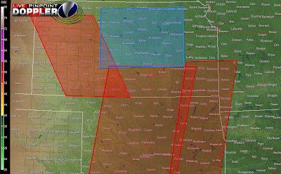

Monday Night Outlook
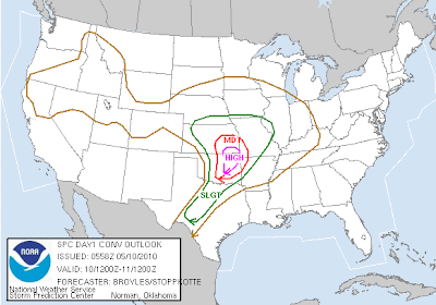
Sunday, May 9, 2010
Sunday Afternoon Update
Latest SPC convective outlook corroborates my thoughts from late last night, as a dangerous and volatile situation will likely unfold tomorrow afternoon and evening in south-central and southeast KS, southwest MO, and northeast OK. As for KC- 1 thing is key to the forecast for tomorrow. I believe the SPC kept the moderate risk just out of the metro because of the relatively low CAPE forecast on many of the model runs. If we can get sufficient daytime heating then the outbreak that is already forecast south of here could move northward. The latest GFS runs have suggested that this may happen with CAPE values close to 3000 j/kg late tomorrow night. For now, I'll give this forecast: severe thunderstorms with large hail, damaging winds, and maybe an isolated tornado for the metro area, sometime between 10PM and 2AM tomorrow night / Tuesday morning. Earlier in the day, showers with the possibility of some small hail will affect the area, moving out in the afternoon. Depending on how long the sun can come out for, KC will need to watch tomorrow night's situation closely. This is evolving into an extremely dangerous situation for a region near KC. . . so surrounding areas, including KC, need to pay close attention to ANY forecast variance.
Early AM Update
SPC has updated their Day 2 convective outlook- KC is on the far northeast edge of the new MODERATE risk area as shown below. This is relatively in line with my belief that while a critical situation will evolve south of here in relation to tornadoes, KC's best bet will be very large hail and gusty winds. Isolated tornadoes will still be possible, especially in discrete storms, something to watch much more closely than we normally would in spring events. If daytime heating increases our CAPE values may skyrocket leading
to increased tornado threat. I'll update in the morning; we should have a much better grasp on the situation late tomorrow. SPC outlook below.
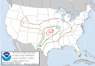
Saturday, May 8, 2010
Late Saturday Thoughts on Monday
From the latest NWS Hazardous Weather Outlook. . .
A POTENTIALLY VOLATILE SETUP EXISTS ACROSS THE OUTLOOK AREA MONDAY EVENING AND OVERNIGHT...WITH TORNADOES...LARGE HAIL AND DAMAGING WINDS ALL POSSIBLE AS SUPERCELL THUNDERSTORMS TRACK EASTWARD...ALONG WITH THE THREAT OF FLASH FLOODING.
11:30 EDIT
Not much different in tonight's 00z runs for 00z Tuesday (7PM Monday). Low should still be well to the southwest, and a number of the different models indicate highest cape levels will be south and southwest of the city where a very large outbreak of tornadoes will occur. As for KC- right now it appears that we'll be located in the warm sector, but that storms will reach us likely sometime around 10PM Monday if models verify. CAPE/Craven-Brooks levels remain surprisingly low. . . but other instability/supercell/tornado parameters are supportive of continued tornado threat in the thunderstorms reaching us late in the night, which the NWS echos in their latest outlook. To me, far southeast KS and northeast OK has the highest threat of dangerous storms, and as long-term CAPE outlooks are often somewhat deceptive. . . I would say forecasts for this area will continue to need close attention. While I think it is apparent that large hail and winds will threaten the area, the tornado threat is a little less clear. The NWS and SPC seem to be sold on a higher threat for KC, but I am not.
If I was to make a forecast right now, I would say storms will fire very late in the evening along the dryline up to the triple-point, and a significant tornado situation will likely unfold from east OK into southeast KS, moving into extreme west MO and NW AK overnight. As the thunderstorms retain their surface based supercellular structure but move into an area of lower instability, a very large hail threat will likely evolve for the metro area.
However, that may change. I will update with the 1AM Day 2 SPC convective outlook, and see where things stand then. Shear values are off the charts for tornadoes here, although I believe instability may be in question Monday night. Lets see how the SPC interprets things in a couple of hours, and I'll look back through the model runs to see if I can corroborate what they are predicting.
For now, please pay close attention to Monday night's forecast. . . as a very dangerous situation will likely evolve somewhere in this region, but how widespread and late that will continue for is a matter to be reviewed many more times.
Monday's Complex Setup
5:30 PM EDIT
NWS EAX forecast discussion updated; appears that local forecasters believe the supercells may persist long enough to enter our area and, especially with the triple point so close by, continue to have the potential to contain tornadoes. The relevant part of the discussion follows.
SEVERE THUNDERSTORMS SHOULD ERUPT THROUGH CENTRAL PORTIONS OF KANSAS. GIVEN THE AMPLE SHEAR AND THE ORIENTATION OF THAT SHEAR ACROSS THE DRYLINE SUPERCELLS WILL BE LIKELY. THIS ACTIVITY WILL SHIFT TO THE EAST WITH THE TRIPLE POINT LIKELY TO BE IN WESTERN PORTIONS OF THE FORECAST AREA. WHAT IS VERY CONCERNING WITH THIS POTENTIALY SIGNIFICANT SEVERE EVENT IS THAT DUE TO STRONG FORCING AND STRONG SURFACE WINDS...THE ENVIRONMENT MAY STAY SURFACE BASED WELL INTO THE EVENING AND EVEN CLOSE TO MIDNIGHT. WITH HIGH HELICITY VALUES WITHIN THE WARM SECTOR AND VERY HIGH SHEAR WE COULD SEE SUPERCELLS PERSISTING WELL AFTER DARK WITH TORNADOES A DISTINCT POSSIBLY.
PREVIOUS ENTRY BELOW
*************************
3 days away from a massive storm system that will eject into the plains creating the potential for significant severe weather, and yet the forecast is still too complex to make any accurate predictions. The latest SPC SREF (short range ensemble forecast) run will be out at any time. . . and if it's anything like the last run, KC will be deep within the prime zone for supercell development, and on the edge of an unusually high (5-7) significant tornado parameter. Interestingly, the SREF models have been trying to push to dryline with 60+ dew points farther north and east. Today's GFS and ECMWF runs have kept the surface low in far south central KS for 00z (7PM) Tuesday, and keeping the highest CAPE values in north OK and south KS- possibly over 3000 j/kg. The SREF runs have KC on the northeast edge of high Craven-Brooks parameters, and within an area of significant tornado ingredients sometime after 00z Tuesday. It looks as though the LLJ (low level jet) will force the dryline very quickly to the north and east, along with the SFC (surface) low, moving north of KC sometime in the early morning hours of Tuesday. Whether or not the cold front will overtake the dryline and whether or not KC will be north or south of the warm front will likely be major players in our severe weather threat. If strong low level winds push the cold front into the dryline, our severe weather threat would primarily be late night linear hail producers and strong wind gusts. If the dry line can stay isolated from the cold front, then shear profiles will likely be more favorable for continued supercell thunderstorms late into the night, although eventually a linear squall will develop somewhere. Thunderstorms are likely earlier in the day as the warm front moves northward, and if the front stays south of KC late into the afternoon, large hail could be a significant threat right around the front. If the warm front moves through, extreme low level moisture and sufficient temps will put KC in the warm sector, and thunderstorms forming along the dryline, north to the triple-point, and points east will likely be supercellular with explosive development and a high probability for vertical rotation. Right now, the likeliest area for significant tornado development (primarily to do this area being protected from much of the model uncertainty) is south central / southeast KS into northeast OK sometime in the afternoon. If the low moves faster as some GFS runs have suggested or a strong cap holds until late evening, this risk area will likely shift closer to KC. We'll have to wait for further model trends before making an accurate prediction, one which will likely wait until Monday morning. Right now, none of the models seem to be able to consistently plot the warm front, putting KC in a zone of major uncertainty. Regardless, strong thunderstorms with large hail and gusty winds will be very likely overnight Monday into early Tuesday morning. But, our strategic placement within the warm sector and position of the SFC low/dry line will likely be major players in our supercell and tornado threat.
Somewhere in the plains there is likely to be a significant tornado outbreak- but where? We'll just have to speculate for now.
Below is the current GFS 00z surface setup for Monday night. Warm front position right now, like I said, is more of a guessing game than anything.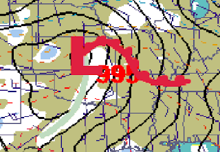

Subscribe to:
Comments (Atom)
